You are here: Home > Network List > US - United States National Seismic Network Stations List
> Station DGMT Dagmar, Montana, USA > Earthquake Result Viewer
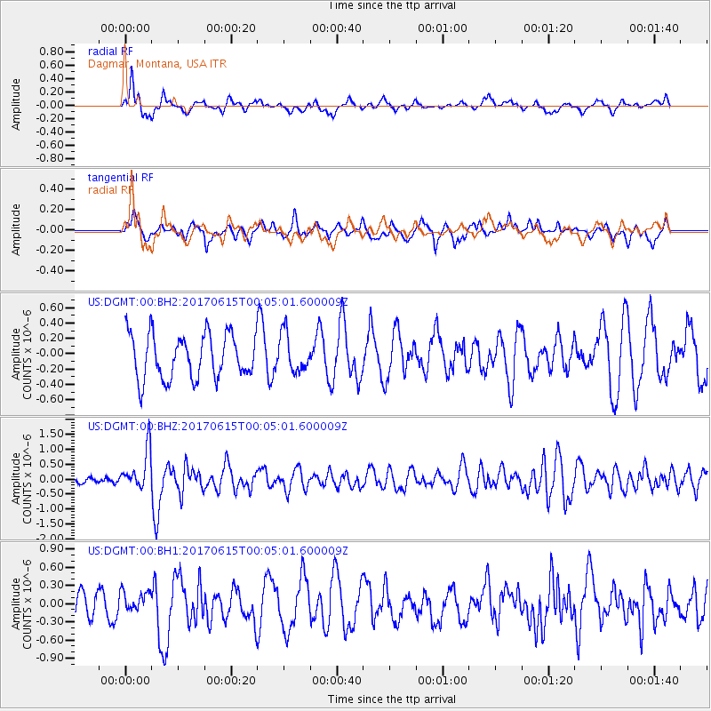
DGMT Dagmar, Montana, USA - Earthquake Result Viewer
*The percent match for this event was below the threshold and hence no stack was calculated.
| Earthquake location: |
Near Coast Of Oaxaca, Mexico |
| Earthquake latitude/longitude: |
15.4/-97.1 |
| Earthquake time(UTC): |
2017/06/14 (165) 23:58:52 GMT |
| Earthquake Depth: |
6.9 km |
| Earthquake Magnitude: |
5.5 Mww |
| Earthquake Catalog/Contributor: |
NEIC PDE/us |
|
| Network: |
US United States National Seismic Network |
| Station: |
DGMT Dagmar, Montana, USA |
| Lat/Lon: |
48.47 N/104.20 W |
| Elevation: |
0.0 m |
|
| Distance: |
33.5 deg |
| Az: |
351.426 deg |
| Baz: |
167.519 deg |
| Ray Param: |
$rayparam |
*The percent match for this event was below the threshold and hence was not used in the summary stack. |
|
| Radial Match: |
55.180668 % |
| Radial Bump: |
400 |
| Transverse Match: |
52.588783 % |
| Transverse Bump: |
400 |
| SOD ConfigId: |
2140511 |
| Insert Time: |
2017-06-28 15:53:23.548 +0000 |
| GWidth: |
2.5 |
| Max Bumps: |
400 |
| Tol: |
0.001 |
|
Signal To Noise
| Channel | StoN | STA | LTA |
| US:DGMT:00:BHZ:20170615T00:05:01.600009Z | 6.077857 | 6.764582E-7 | 1.112988E-7 |
| US:DGMT:00:BH1:20170615T00:05:01.600009Z | 0.52100646 | 1.5919156E-7 | 3.0554622E-7 |
| US:DGMT:00:BH2:20170615T00:05:01.600009Z | 0.8769491 | 2.5387334E-7 | 2.894961E-7 |
| Arrivals |
| Ps | |
| PpPs | |
| PsPs/PpSs | |


