You are here: Home > Network List > US - United States National Seismic Network Stations List
> Station ERPA Erie, Pennsylvania, USA > Earthquake Result Viewer
ERPA Erie, Pennsylvania, USA - Earthquake Result Viewer

| Earthquake location: |
Near Coast Of Oaxaca, Mexico |
| Earthquake latitude/longitude: |
15.4/-97.1 |
| Earthquake time(UTC): |
2017/06/14 (165) 23:58:52 GMT |
| Earthquake Depth: |
6.9 km |
| Earthquake Magnitude: |
5.5 Mww |
| Earthquake Catalog/Contributor: |
NEIC PDE/us |
|
| Network: |
US United States National Seismic Network |
| Station: |
ERPA Erie, Pennsylvania, USA |
| Lat/Lon: |
42.12 N/79.99 W |
| Elevation: |
306 m |
|
| Distance: |
30.5 deg |
| Az: |
25.553 deg |
| Baz: |
214.009 deg |
| Ray Param: |
0.079327404 |
| Estimated Moho Depth: |
18.75 km |
| Estimated Crust Vp/Vs: |
1.82 |
| Assumed Crust Vp: |
6.419 km/s |
| Estimated Crust Vs: |
3.527 km/s |
| Estimated Crust Poisson's Ratio: |
0.28 |
|
| Radial Match: |
90.34185 % |
| Radial Bump: |
400 |
| Transverse Match: |
59.14416 % |
| Transverse Bump: |
400 |
| SOD ConfigId: |
2140511 |
| Insert Time: |
2017-06-28 15:53:27.197 +0000 |
| GWidth: |
2.5 |
| Max Bumps: |
400 |
| Tol: |
0.001 |
|
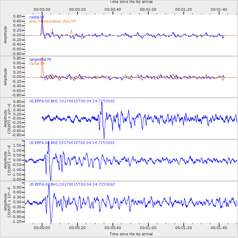
Signal To Noise
| Channel | StoN | STA | LTA |
| US:ERPA:00:BHZ:20170615T00:04:34.725009Z | 9.342482 | 8.5009566E-7 | 9.0992486E-8 |
| US:ERPA:00:BH1:20170615T00:04:34.725009Z | 4.6388974 | 4.2550684E-7 | 9.172585E-8 |
| US:ERPA:00:BH2:20170615T00:04:34.725009Z | 4.000129 | 3.0179183E-7 | 7.544552E-8 |
| Arrivals |
| Ps | 2.6 SECOND |
| PpPs | 7.6 SECOND |
| PsPs/PpSs | 10 SECOND |


