You are here: Home > Network List > UO - University of Oregon Regional Network Stations List
> Station PF27 Portland, OR, USA > Earthquake Result Viewer
PF27 Portland, OR, USA - Earthquake Result Viewer
| Earthquake location: |
South Of Kermadec Islands |
| Earthquake latitude/longitude: |
-33.3/-177.8 |
| Earthquake time(UTC): |
2020/06/18 (170) 12:49:53 GMT |
| Earthquake Depth: |
10 km |
| Earthquake Magnitude: |
7.4 Mww |
| Earthquake Catalog/Contributor: |
NEIC PDE/us |
|
| Network: |
UO University of Oregon Regional Network |
| Station: |
PF27 Portland, OR, USA |
| Lat/Lon: |
45.54 N/122.76 W |
| Elevation: |
332 m |
|
| Distance: |
93.0 deg |
| Az: |
35.238 deg |
| Baz: |
223.445 deg |
| Ray Param: |
0.04136231 |
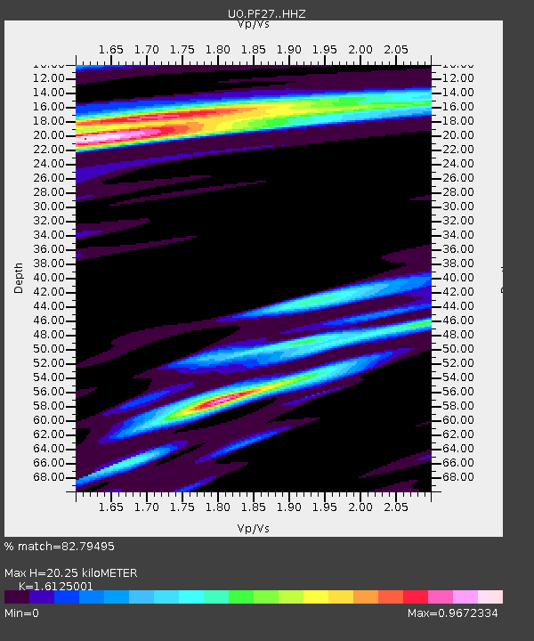
| Estimated Moho Depth: |
20.25 km |
| Estimated Crust Vp/Vs: |
1.61 |
| Assumed Crust Vp: |
6.566 km/s |
| Estimated Crust Vs: |
4.072 km/s |
| Estimated Crust Poisson's Ratio: |
0.19 |
|
| Radial Match: |
82.79495 % |
| Radial Bump: |
400 |
| Transverse Match: |
69.46294 % |
| Transverse Bump: |
400 |
| SOD ConfigId: |
21709731 |
| Insert Time: |
2020-07-02 13:10:14.825 +0000 |
| GWidth: |
2.5 |
| Max Bumps: |
400 |
| Tol: |
0.001 |
|

Signal To Noise
| Channel | StoN | STA | LTA |
| UO:PF27: :HHZ:20200618T13:02:35.460013Z | 14.164428 | 3.816962E-6 | 2.694752E-7 |
| UO:PF27: :HHN:20200618T13:02:35.460013Z | 1.2054802 | 7.906683E-7 | 6.558949E-7 |
| UO:PF27: :HHE:20200618T13:02:35.460013Z | 1.0679002 | 4.2454806E-7 | 3.9755406E-7 |
| Arrivals |
| Ps | 1.9 SECOND |
| PpPs | 7.9 SECOND |
| PsPs/PpSs | 9.8 SECOND |


