You are here: Home > Network List > US - United States National Seismic Network Stations List
> Station BW06 Boulder Array Site 6 (Pinedale), Wyoming, USA > Earthquake Result Viewer
BW06 Boulder Array Site 6 (Pinedale), Wyoming, USA - Earthquake Result Viewer
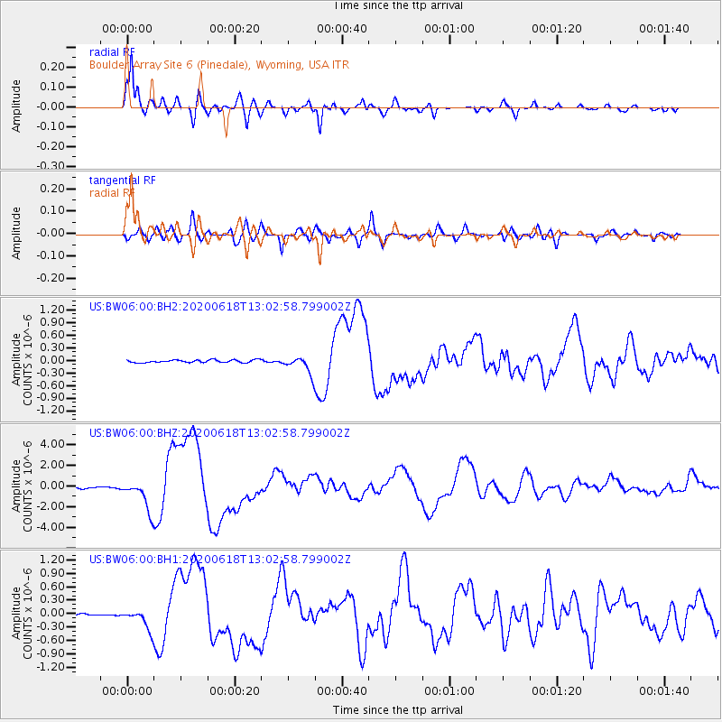
| Earthquake location: |
South Of Kermadec Islands |
| Earthquake latitude/longitude: |
-33.3/-177.8 |
| Earthquake time(UTC): |
2020/06/18 (170) 12:49:53 GMT |
| Earthquake Depth: |
10 km |
| Earthquake Magnitude: |
7.4 Mww |
| Earthquake Catalog/Contributor: |
NEIC PDE/us |
|
| Network: |
US United States National Seismic Network |
| Station: |
BW06 Boulder Array Site 6 (Pinedale), Wyoming, USA |
| Lat/Lon: |
42.77 N/109.56 W |
| Elevation: |
2224 m |
|
| Distance: |
98.1 deg |
| Az: |
43.714 deg |
| Baz: |
231.812 deg |
| Ray Param: |
0.040000856 |
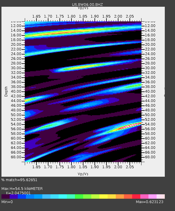
| Estimated Moho Depth: |
54.5 km |
| Estimated Crust Vp/Vs: |
2.05 |
| Assumed Crust Vp: |
6.161 km/s |
| Estimated Crust Vs: |
3.009 km/s |
| Estimated Crust Poisson's Ratio: |
0.34 |
|
| Radial Match: |
95.62651 % |
| Radial Bump: |
400 |
| Transverse Match: |
86.20957 % |
| Transverse Bump: |
400 |
| SOD ConfigId: |
21709731 |
| Insert Time: |
2020-07-02 13:10:36.041 +0000 |
| GWidth: |
2.5 |
| Max Bumps: |
400 |
| Tol: |
0.001 |
|
Signal To Noise
| Channel | StoN | STA | LTA |
| US:BW06:00:BHZ:20200618T13:02:58.799002Z | 20.100805 | 1.4934251E-6 | 7.429678E-8 |
| US:BW06:00:BH1:20200618T13:02:58.799002Z | 5.6164393 | 2.3259088E-7 | 4.1412516E-8 |
| US:BW06:00:BH2:20200618T13:02:58.799002Z | 6.885205 | 2.1163277E-7 | 3.0737322E-8 |
| Arrivals |
| Ps | 9.4 SECOND |
| PpPs | 27 SECOND |
| PsPs/PpSs | 36 SECOND |


