You are here: Home > Network List > US - United States National Seismic Network Stations List
> Station MNTX Cornudas Mountains, Texas, USA > Earthquake Result Viewer
MNTX Cornudas Mountains, Texas, USA - Earthquake Result Viewer

| Earthquake location: |
South Of Kermadec Islands |
| Earthquake latitude/longitude: |
-33.3/-177.8 |
| Earthquake time(UTC): |
2020/06/18 (170) 12:49:53 GMT |
| Earthquake Depth: |
10 km |
| Earthquake Magnitude: |
7.4 Mww |
| Earthquake Catalog/Contributor: |
NEIC PDE/us |
|
| Network: |
US United States National Seismic Network |
| Station: |
MNTX Cornudas Mountains, Texas, USA |
| Lat/Lon: |
31.70 N/105.38 W |
| Elevation: |
404 m |
|
| Distance: |
94.0 deg |
| Az: |
54.565 deg |
| Baz: |
233.186 deg |
| Ray Param: |
0.04113603 |
| Estimated Moho Depth: |
14.75 km |
| Estimated Crust Vp/Vs: |
1.68 |
| Assumed Crust Vp: |
6.361 km/s |
| Estimated Crust Vs: |
3.797 km/s |
| Estimated Crust Poisson's Ratio: |
0.22 |
|
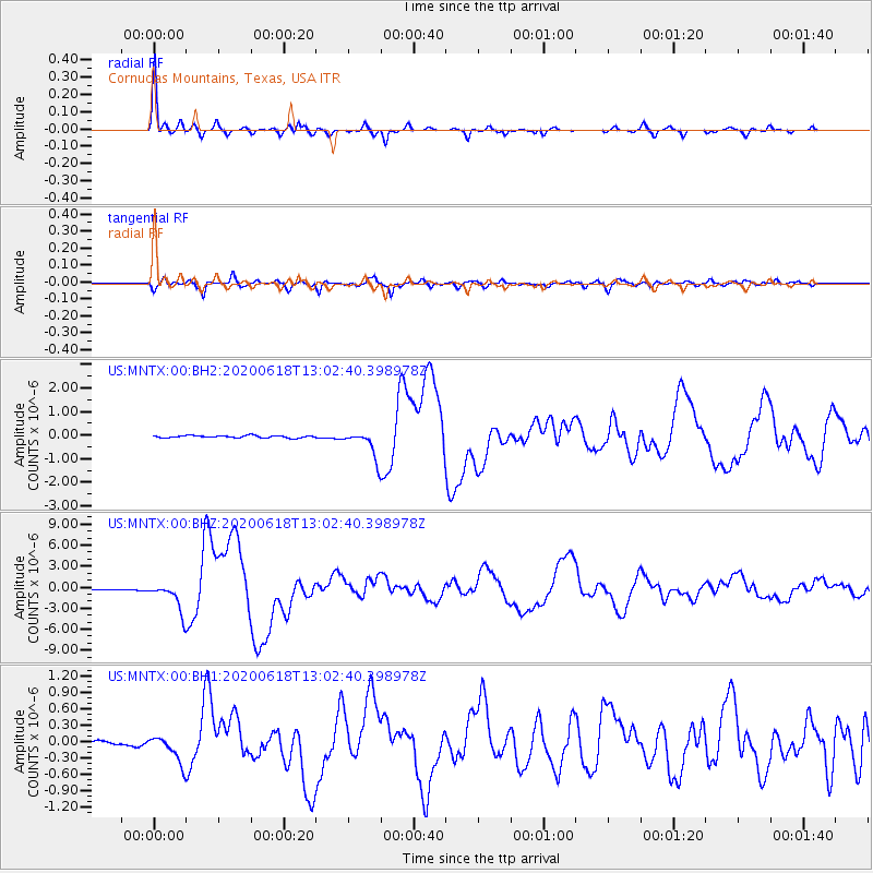
| Radial Match: |
97.776924 % |
| Radial Bump: |
346 |
| Transverse Match: |
94.14469 % |
| Transverse Bump: |
400 |
| SOD ConfigId: |
21709731 |
| Insert Time: |
2020-07-02 13:10:45.354 +0000 |
| GWidth: |
2.5 |
| Max Bumps: |
400 |
| Tol: |
0.001 |
|
Signal To Noise
| Channel | StoN | STA | LTA |
| US:MNTX:00:BHZ:20200618T13:02:40.398978Z | 46.880127 | 2.1131698E-6 | 4.5076025E-8 |
| US:MNTX:00:BH1:20200618T13:02:40.398978Z | 5.3747087 | 2.5662555E-7 | 4.7746877E-8 |
| US:MNTX:00:BH2:20200618T13:02:40.398978Z | 12.229001 | 5.8631895E-7 | 4.7944962E-8 |
| Arrivals |
| Ps | 1.6 SECOND |
| PpPs | 6.1 SECOND |
| PsPs/PpSs | 7.7 SECOND |


