You are here: Home > Network List > UU - University of Utah Regional Network Stations List
> Station CCUT Cedar City, UT, USA > Earthquake Result Viewer
CCUT Cedar City, UT, USA - Earthquake Result Viewer
| Earthquake location: |
South Of Kermadec Islands |
| Earthquake latitude/longitude: |
-33.3/-177.8 |
| Earthquake time(UTC): |
2020/06/18 (170) 12:49:53 GMT |
| Earthquake Depth: |
10 km |
| Earthquake Magnitude: |
7.4 Mww |
| Earthquake Catalog/Contributor: |
NEIC PDE/us |
|
| Network: |
UU University of Utah Regional Network |
| Station: |
CCUT Cedar City, UT, USA |
| Lat/Lon: |
37.55 N/113.36 W |
| Elevation: |
2127 m |
|
| Distance: |
92.6 deg |
| Az: |
45.884 deg |
| Baz: |
229.162 deg |
| Ray Param: |
0.041436475 |
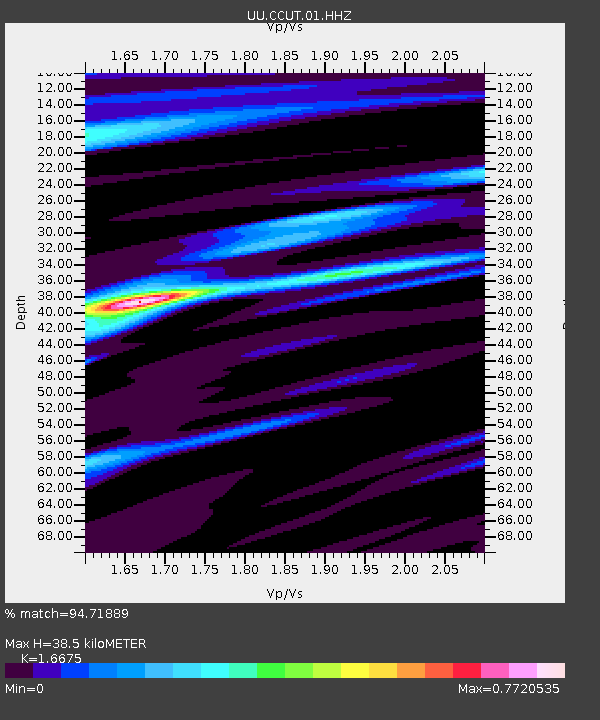
| Estimated Moho Depth: |
38.5 km |
| Estimated Crust Vp/Vs: |
1.67 |
| Assumed Crust Vp: |
6.194 km/s |
| Estimated Crust Vs: |
3.715 km/s |
| Estimated Crust Poisson's Ratio: |
0.22 |
|
| Radial Match: |
94.71889 % |
| Radial Bump: |
357 |
| Transverse Match: |
86.858864 % |
| Transverse Bump: |
400 |
| SOD ConfigId: |
21709731 |
| Insert Time: |
2020-07-02 13:11:05.573 +0000 |
| GWidth: |
2.5 |
| Max Bumps: |
400 |
| Tol: |
0.001 |
|

Signal To Noise
| Channel | StoN | STA | LTA |
| UU:CCUT:01:HHZ:20200618T13:02:33.604971Z | 4.8396716 | 5.4398635E-7 | 1.1240151E-7 |
| UU:CCUT:01:HHN:20200618T13:02:33.604971Z | 2.477134 | 2.7893043E-7 | 1.1260207E-7 |
| UU:CCUT:01:HHE:20200618T13:02:33.604971Z | 1.1816174 | 1.3145521E-7 | 1.1125024E-7 |
| Arrivals |
| Ps | 4.2 SECOND |
| PpPs | 16 SECOND |
| PsPs/PpSs | 20 SECOND |


