You are here: Home > Network List > UW - Pacific Northwest Regional Seismic Network Stations List
> Station CCRK Sunnyside, WA, USA > Earthquake Result Viewer
CCRK Sunnyside, WA, USA - Earthquake Result Viewer
| Earthquake location: |
South Of Kermadec Islands |
| Earthquake latitude/longitude: |
-33.3/-177.8 |
| Earthquake time(UTC): |
2020/06/18 (170) 12:49:53 GMT |
| Earthquake Depth: |
10 km |
| Earthquake Magnitude: |
7.4 Mww |
| Earthquake Catalog/Contributor: |
NEIC PDE/us |
|
| Network: |
UW Pacific Northwest Regional Seismic Network |
| Station: |
CCRK Sunnyside, WA, USA |
| Lat/Lon: |
46.56 N/119.85 W |
| Elevation: |
561 m |
|
| Distance: |
95.1 deg |
| Az: |
35.974 deg |
| Baz: |
225.479 deg |
| Ray Param: |
0.040879235 |
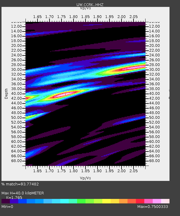
| Estimated Moho Depth: |
40.0 km |
| Estimated Crust Vp/Vs: |
1.76 |
| Assumed Crust Vp: |
6.419 km/s |
| Estimated Crust Vs: |
3.637 km/s |
| Estimated Crust Poisson's Ratio: |
0.26 |
|
| Radial Match: |
93.77482 % |
| Radial Bump: |
400 |
| Transverse Match: |
86.39896 % |
| Transverse Bump: |
400 |
| SOD ConfigId: |
21709731 |
| Insert Time: |
2020-07-02 13:12:02.380 +0000 |
| GWidth: |
2.5 |
| Max Bumps: |
400 |
| Tol: |
0.001 |
|

Signal To Noise
| Channel | StoN | STA | LTA |
| UW:CCRK: :HHZ:20200618T13:02:45.229971Z | 21.309305 | 2.9085406E-6 | 1.3649158E-7 |
| UW:CCRK: :HHN:20200618T13:02:45.229971Z | 10.998799 | 6.8829837E-7 | 6.257941E-8 |
| UW:CCRK: :HHE:20200618T13:02:45.229971Z | 4.4136286 | 3.875013E-7 | 8.7796536E-8 |
| Arrivals |
| Ps | 4.9 SECOND |
| PpPs | 17 SECOND |
| PsPs/PpSs | 22 SECOND |


