You are here: Home > Network List > UW - Pacific Northwest Regional Seismic Network Stations List
> Station PRO Prosser, WA, USA (was ISC code PRW) > Earthquake Result Viewer
PRO Prosser, WA, USA (was ISC code PRW) - Earthquake Result Viewer
| Earthquake location: |
South Of Kermadec Islands |
| Earthquake latitude/longitude: |
-33.3/-177.8 |
| Earthquake time(UTC): |
2020/06/18 (170) 12:49:53 GMT |
| Earthquake Depth: |
10 km |
| Earthquake Magnitude: |
7.4 Mww |
| Earthquake Catalog/Contributor: |
NEIC PDE/us |
|
| Network: |
UW Pacific Northwest Regional Seismic Network |
| Station: |
PRO Prosser, WA, USA (was ISC code PRW) |
| Lat/Lon: |
46.21 N/119.69 W |
| Elevation: |
553 m |
|
| Distance: |
94.9 deg |
| Az: |
36.304 deg |
| Baz: |
225.571 deg |
| Ray Param: |
0.040919755 |
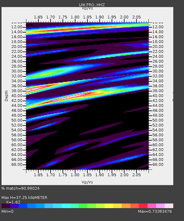
| Estimated Moho Depth: |
37.25 km |
| Estimated Crust Vp/Vs: |
1.62 |
| Assumed Crust Vp: |
6.419 km/s |
| Estimated Crust Vs: |
3.962 km/s |
| Estimated Crust Poisson's Ratio: |
0.19 |
|
| Radial Match: |
90.99024 % |
| Radial Bump: |
400 |
| Transverse Match: |
68.240074 % |
| Transverse Bump: |
400 |
| SOD ConfigId: |
21709731 |
| Insert Time: |
2020-07-02 13:12:56.972 +0000 |
| GWidth: |
2.5 |
| Max Bumps: |
400 |
| Tol: |
0.001 |
|

Signal To Noise
| Channel | StoN | STA | LTA |
| UW:PRO: :HHZ:20200618T13:02:44.510Z | 34.260292 | 2.6812488E-6 | 7.8261124E-8 |
| UW:PRO: :HHN:20200618T13:02:44.510Z | 6.229967 | 4.3870955E-7 | 7.041924E-8 |
| UW:PRO: :HHE:20200618T13:02:44.510Z | 5.519825 | 4.661059E-7 | 8.4442156E-8 |
| Arrivals |
| Ps | 3.7 SECOND |
| PpPs | 15 SECOND |
| PsPs/PpSs | 19 SECOND |


