You are here: Home > Network List > TX - Texas Seismological Network Stations List
> Station DRIO Del Rio > Earthquake Result Viewer
DRIO Del Rio - Earthquake Result Viewer
| Earthquake location: |
South Of Kermadec Islands |
| Earthquake latitude/longitude: |
-33.3/-177.9 |
| Earthquake time(UTC): |
2020/06/18 (170) 16:11:39 GMT |
| Earthquake Depth: |
10 km |
| Earthquake Magnitude: |
5.5 mb |
| Earthquake Catalog/Contributor: |
NEIC PDE/us |
|
| Network: |
TX Texas Seismological Network |
| Station: |
DRIO Del Rio |
| Lat/Lon: |
29.42 N/100.62 W |
| Elevation: |
354 m |
|
| Distance: |
96.1 deg |
| Az: |
58.874 deg |
| Baz: |
235.303 deg |
| Ray Param: |
0.04060991 |
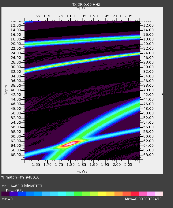
| Estimated Moho Depth: |
63.0 km |
| Estimated Crust Vp/Vs: |
1.80 |
| Assumed Crust Vp: |
6.12 km/s |
| Estimated Crust Vs: |
3.405 km/s |
| Estimated Crust Poisson's Ratio: |
0.28 |
|
| Radial Match: |
99.948616 % |
| Radial Bump: |
6 |
| Transverse Match: |
98.35189 % |
| Transverse Bump: |
122 |
| SOD ConfigId: |
21709731 |
| Insert Time: |
2020-07-02 16:22:20.185 +0000 |
| GWidth: |
2.5 |
| Max Bumps: |
400 |
| Tol: |
0.001 |
|

Signal To Noise
| Channel | StoN | STA | LTA |
| TX:DRIO:00:HHZ:20200618T16:24:35.960019Z | 0.56035614 | 3.319697E-8 | 5.9242627E-8 |
| TX:DRIO:00:HH1:20200618T16:24:35.960019Z | 0.56439066 | 1.5518218E-8 | 2.7495526E-8 |
| TX:DRIO:00:HH2:20200618T16:24:35.960019Z | 0.5607125 | 1.6863925E-8 | 3.007589E-8 |
| Arrivals |
| Ps | 8.4 SECOND |
| PpPs | 28 SECOND |
| PsPs/PpSs | 37 SECOND |


