You are here: Home > Network List > IW - Intermountain West Stations List
> Station MOOW Moose Ponds, Wyoming, USA > Earthquake Result Viewer
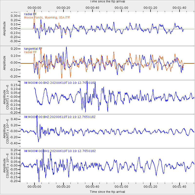
MOOW Moose Ponds, Wyoming, USA - Earthquake Result Viewer
*The percent match for this event was below the threshold and hence no stack was calculated.
| Earthquake location: |
Fiji Islands Region |
| Earthquake latitude/longitude: |
-17.5/-178.9 |
| Earthquake time(UTC): |
2020/06/19 (171) 10:07:55 GMT |
| Earthquake Depth: |
535 km |
| Earthquake Magnitude: |
5.6 Mww |
| Earthquake Catalog/Contributor: |
NEIC PDE/us |
|
| Network: |
IW Intermountain West |
| Station: |
MOOW Moose Ponds, Wyoming, USA |
| Lat/Lon: |
43.75 N/110.74 W |
| Elevation: |
2128 m |
|
| Distance: |
87.0 deg |
| Az: |
42.349 deg |
| Baz: |
242.533 deg |
| Ray Param: |
$rayparam |
*The percent match for this event was below the threshold and hence was not used in the summary stack. |
|
| Radial Match: |
46.96767 % |
| Radial Bump: |
400 |
| Transverse Match: |
44.999187 % |
| Transverse Bump: |
400 |
| SOD ConfigId: |
21709731 |
| Insert Time: |
2020-07-03 10:22:06.623 +0000 |
| GWidth: |
2.5 |
| Max Bumps: |
400 |
| Tol: |
0.001 |
|
Signal To Noise
| Channel | StoN | STA | LTA |
| IW:MOOW:00:BHZ:20200619T10:19:12.765018Z | 3.3634841 | 1.9540647E-7 | 5.8096443E-8 |
| IW:MOOW:00:BH1:20200619T10:19:12.765018Z | 1.339463 | 6.320439E-8 | 4.7186365E-8 |
| IW:MOOW:00:BH2:20200619T10:19:12.765018Z | 1.433698 | 7.690351E-8 | 5.3639962E-8 |
| Arrivals |
| Ps | |
| PpPs | |
| PsPs/PpSs | |


