You are here: Home > Network List > KN - Kyrgyz Seismic Telemetry Network Stations List
> Station ULHL KN.ULHL > Earthquake Result Viewer
ULHL KN.ULHL - Earthquake Result Viewer

| Earthquake location: |
Eastern Honshu, Japan |
| Earthquake latitude/longitude: |
39.8/141.5 |
| Earthquake time(UTC): |
2008/07/23 (205) 15:26:19 GMT |
| Earthquake Depth: |
108 km |
| Earthquake Magnitude: |
6.6 MB, 6.8 MW, 6.8 MW |
| Earthquake Catalog/Contributor: |
WHDF/NEIC |
|
| Network: |
KN Kyrgyz Seismic Telemetry Network |
| Station: |
ULHL KN.ULHL |
| Lat/Lon: |
42.25 N/76.24 E |
| Elevation: |
2040 m |
|
| Distance: |
48.2 deg |
| Az: |
295.226 deg |
| Baz: |
69.813 deg |
| Ray Param: |
0.06916119 |
| Estimated Moho Depth: |
44.0 km |
| Estimated Crust Vp/Vs: |
1.88 |
| Assumed Crust Vp: |
6.306 km/s |
| Estimated Crust Vs: |
3.363 km/s |
| Estimated Crust Poisson's Ratio: |
0.30 |
|
| Radial Match: |
95.20253 % |
| Radial Bump: |
384 |
| Transverse Match: |
84.07733 % |
| Transverse Bump: |
400 |
| SOD ConfigId: |
2504 |
| Insert Time: |
2010-03-08 21:42:40.843 +0000 |
| GWidth: |
2.5 |
| Max Bumps: |
400 |
| Tol: |
0.001 |
|
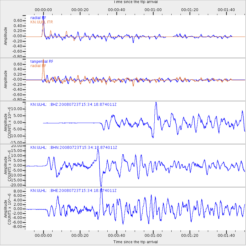
Signal To Noise
| Channel | StoN | STA | LTA |
| KN:ULHL: :BHN:20080723T15:34:18.874011Z | 40.05862 | 3.8149974E-6 | 9.523537E-8 |
| KN:ULHL: :BHE:20080723T15:34:18.874011Z | 22.281504 | 1.2949719E-6 | 5.811869E-8 |
| KN:ULHL: :BHZ:20080723T15:34:18.874011Z | 34.725605 | 2.1758926E-6 | 6.26596E-8 |
| Arrivals |
| Ps | 6.4 SECOND |
| PpPs | 19 SECOND |
| PsPs/PpSs | 25 SECOND |


