You are here: Home > Network List > TA - USArray Transportable Network (new EarthScope stations) Stations List
> Station C16K Lisburne Hills, AK, USA > Earthquake Result Viewer
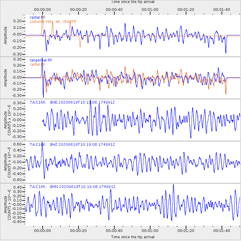
C16K Lisburne Hills, AK, USA - Earthquake Result Viewer
*The percent match for this event was below the threshold and hence no stack was calculated.
| Earthquake location: |
Fiji Islands Region |
| Earthquake latitude/longitude: |
-17.5/-178.9 |
| Earthquake time(UTC): |
2020/06/19 (171) 10:07:55 GMT |
| Earthquake Depth: |
535 km |
| Earthquake Magnitude: |
5.6 Mww |
| Earthquake Catalog/Contributor: |
NEIC PDE/us |
|
| Network: |
TA USArray Transportable Network (new EarthScope stations) |
| Station: |
C16K Lisburne Hills, AK, USA |
| Lat/Lon: |
68.27 N/165.34 W |
| Elevation: |
102 m |
|
| Distance: |
86.1 deg |
| Az: |
5.025 deg |
| Baz: |
192.976 deg |
| Ray Param: |
$rayparam |
*The percent match for this event was below the threshold and hence was not used in the summary stack. |
|
| Radial Match: |
41.219948 % |
| Radial Bump: |
400 |
| Transverse Match: |
55.8081 % |
| Transverse Bump: |
400 |
| SOD ConfigId: |
21709731 |
| Insert Time: |
2020-07-03 10:26:53.644 +0000 |
| GWidth: |
2.5 |
| Max Bumps: |
400 |
| Tol: |
0.001 |
|
Signal To Noise
| Channel | StoN | STA | LTA |
| TA:C16K: :BHZ:20200619T10:19:08.174991Z | 2.0834906 | 2.8126124E-7 | 1.349952E-7 |
| TA:C16K: :BHN:20200619T10:19:08.174991Z | 0.9343717 | 1.3572695E-7 | 1.4526012E-7 |
| TA:C16K: :BHE:20200619T10:19:08.174991Z | 1.6055701 | 1.5449639E-7 | 9.622526E-8 |
| Arrivals |
| Ps | |
| PpPs | |
| PsPs/PpSs | |


