ULHL KN.ULHL - Earthquake Result Viewer
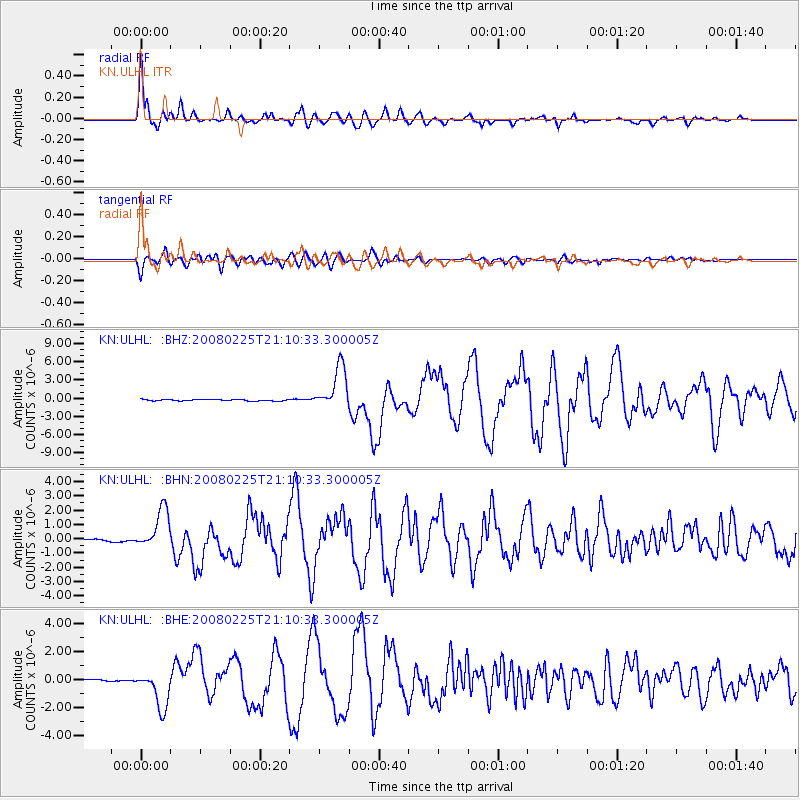
Earthquake location: Southern Sumatra, Indonesia
Earthquake latitude/longitude: -2.2/99.8
Earthquake time(UTC): 2008/02/25 (056) 21:02:18 GMT
Earthquake Depth: 25 km
Earthquake Magnitude: 6.2 MB, 6.6 MS, 6.6 MW, 6.5 MW
Earthquake Catalog/Contributor: WHDF/NEIC
Network: KN Kyrgyz Seismic Telemetry Network
Station: ULHL KN.ULHL
Lat/Lon: 42.25 N/76.24 E
Elevation: 2040 m
Distance: 49.2 deg
Az: 336.895 deg
Baz: 148.122 deg
Ray Param: 0.06884072
Estimated Moho Depth: 51.75 km
Estimated Crust Vp/Vs: 1.77
Assumed Crust Vp: 6.306 km/s
Estimated Crust Vs: 3.558 km/s
Estimated Crust Poisson's Ratio: 0.27
Radial Match: 94.81038 %
Radial Bump: 400
Transverse Match: 87.49826 %
Transverse Bump: 400
SOD ConfigId: 2564
Insert Time: 2010-03-08 21:43:26.458 +0000
GWidth: 2.5
Max Bumps: 400
Tol: 0.001

Signal To Noise

ChannelStoNSTALTA
KN:ULHL: :BHN:20080225T21:10:33.300005Z12.2227621.3736874E-61.1238764E-7
KN:ULHL: :BHE:20080225T21:10:33.300005Z13.7090811.3096751E-69.55334E-8
KN:ULHL: :BHZ:20080225T21:10:33.300005Z28.1492083.521994E-61.2511876E-7
Arrivals
Ps6.7 SECOND
PpPs21 SECOND
PsPs/PpSs28 SECOND