You are here: Home > Network List > TA - USArray Transportable Network (new EarthScope stations) Stations List
> Station K13K Kusilvak Mountain, AK, USA > Earthquake Result Viewer
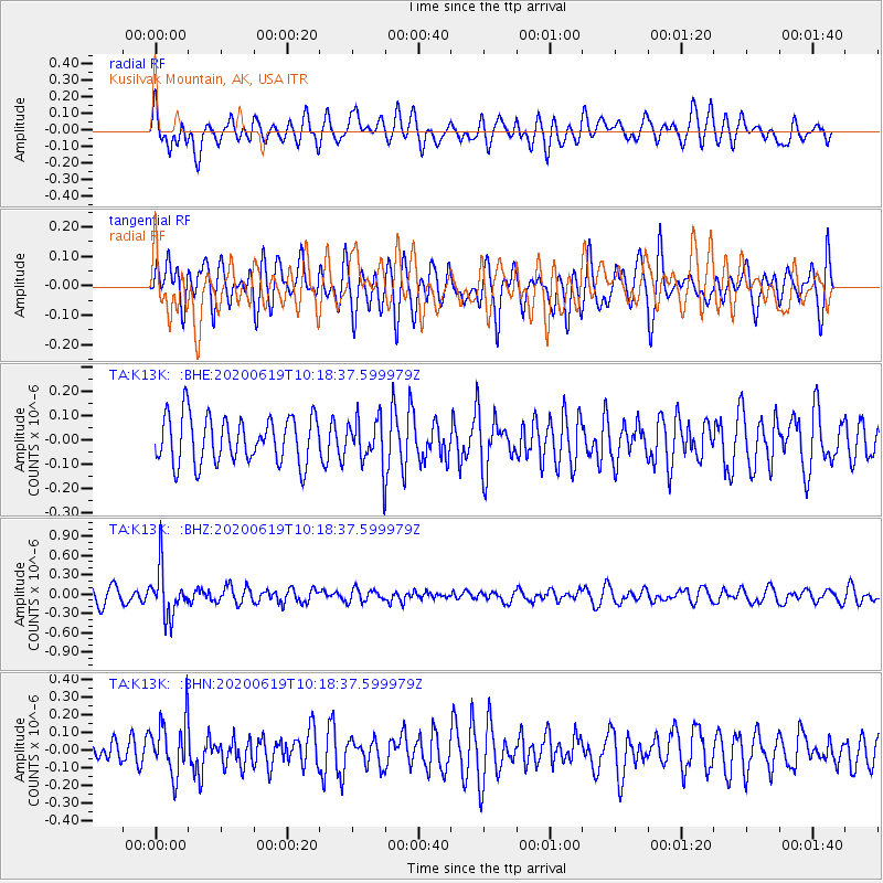
K13K Kusilvak Mountain, AK, USA - Earthquake Result Viewer
*The percent match for this event was below the threshold and hence no stack was calculated.
| Earthquake location: |
Fiji Islands Region |
| Earthquake latitude/longitude: |
-17.5/-178.9 |
| Earthquake time(UTC): |
2020/06/19 (171) 10:07:55 GMT |
| Earthquake Depth: |
535 km |
| Earthquake Magnitude: |
5.6 Mww |
| Earthquake Catalog/Contributor: |
NEIC PDE/us |
|
| Network: |
TA USArray Transportable Network (new EarthScope stations) |
| Station: |
K13K Kusilvak Mountain, AK, USA |
| Lat/Lon: |
61.93 N/164.66 W |
| Elevation: |
204 m |
|
| Distance: |
79.9 deg |
| Az: |
6.796 deg |
| Baz: |
193.817 deg |
| Ray Param: |
$rayparam |
*The percent match for this event was below the threshold and hence was not used in the summary stack. |
|
| Radial Match: |
55.385147 % |
| Radial Bump: |
400 |
| Transverse Match: |
54.472244 % |
| Transverse Bump: |
400 |
| SOD ConfigId: |
21709731 |
| Insert Time: |
2020-07-03 10:28:25.931 +0000 |
| GWidth: |
2.5 |
| Max Bumps: |
400 |
| Tol: |
0.001 |
|
Signal To Noise
| Channel | StoN | STA | LTA |
| TA:K13K: :BHZ:20200619T10:18:37.599979Z | 4.0024624 | 3.7516702E-7 | 9.373405E-8 |
| TA:K13K: :BHN:20200619T10:18:37.599979Z | 1.6300708 | 1.5675846E-7 | 9.6166666E-8 |
| TA:K13K: :BHE:20200619T10:18:37.599979Z | 0.9495744 | 9.2221434E-8 | 9.71187E-8 |
| Arrivals |
| Ps | |
| PpPs | |
| PsPs/PpSs | |


