You are here: Home > Network List > TA - USArray Transportable Network (new EarthScope stations) Stations List
> Station O17K Koliganek, Bristol Bay, AK, USA > Earthquake Result Viewer
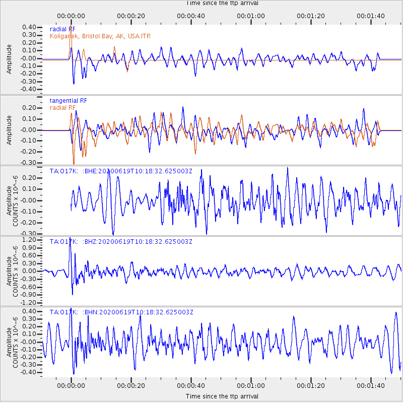
O17K Koliganek, Bristol Bay, AK, USA - Earthquake Result Viewer
*The percent match for this event was below the threshold and hence no stack was calculated.
| Earthquake location: |
Fiji Islands Region |
| Earthquake latitude/longitude: |
-17.5/-178.9 |
| Earthquake time(UTC): |
2020/06/19 (171) 10:07:55 GMT |
| Earthquake Depth: |
535 km |
| Earthquake Magnitude: |
5.6 Mww |
| Earthquake Catalog/Contributor: |
NEIC PDE/us |
|
| Network: |
TA USArray Transportable Network (new EarthScope stations) |
| Station: |
O17K Koliganek, Bristol Bay, AK, USA |
| Lat/Lon: |
59.77 N/157.09 W |
| Elevation: |
156 m |
|
| Distance: |
79.0 deg |
| Az: |
11.047 deg |
| Baz: |
201.192 deg |
| Ray Param: |
$rayparam |
*The percent match for this event was below the threshold and hence was not used in the summary stack. |
|
| Radial Match: |
59.834103 % |
| Radial Bump: |
380 |
| Transverse Match: |
52.191067 % |
| Transverse Bump: |
387 |
| SOD ConfigId: |
21709731 |
| Insert Time: |
2020-07-03 10:29:06.870 +0000 |
| GWidth: |
2.5 |
| Max Bumps: |
400 |
| Tol: |
0.001 |
|
Signal To Noise
| Channel | StoN | STA | LTA |
| TA:O17K: :BHZ:20200619T10:18:32.625003Z | 4.84475 | 4.6943913E-7 | 9.689646E-8 |
| TA:O17K: :BHN:20200619T10:18:32.625003Z | 2.2378838 | 2.2013927E-7 | 9.836939E-8 |
| TA:O17K: :BHE:20200619T10:18:32.625003Z | 1.0391475 | 1.10708065E-7 | 1.0653739E-7 |
| Arrivals |
| Ps | |
| PpPs | |
| PsPs/PpSs | |


