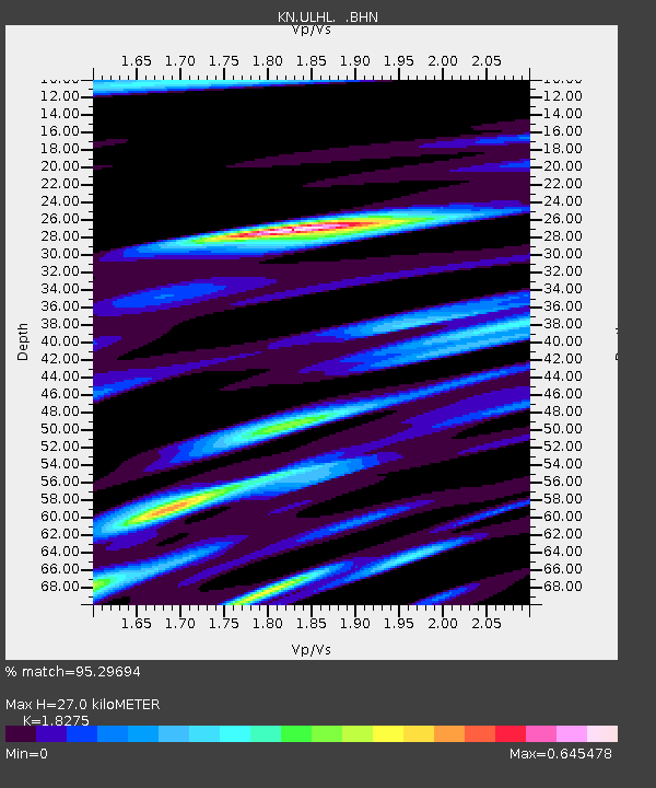
ULHL KN.ULHL - Earthquake Result Viewer

Earthquake location: East Of Kuril Islands
Earthquake latitude/longitude: 46.9/155.2
Earthquake time(UTC): 2009/01/15 (015) 17:49:39 GMT
Earthquake Depth: 36 km
Earthquake Magnitude: 6.9 MB, 7.5 MS, 7.4 MW, 7.4 MW
Earthquake Catalog/Contributor: WHDF/NEIC
Network: KN Kyrgyz Seismic Telemetry Network
Station: ULHL KN.ULHL
Lat/Lon: 42.25 N/76.24 E
Elevation: 2040 m
Distance: 54.2 deg
Az: 296.027 deg
Baz: 56.151 deg
Ray Param: 0.065540396
Estimated Moho Depth: 27.0 km
Estimated Crust Vp/Vs: 1.83
Assumed Crust Vp: 6.306 km/s
Estimated Crust Vs: 3.451 km/s
Estimated Crust Poisson's Ratio: 0.29
Radial Match: 95.29694 %
Radial Bump: 299
Transverse Match: 86.70155 %
Transverse Bump: 400
SOD ConfigId: 2834
Insert Time: 2010-03-08 21:43:57.677 +0000
GWidth: 2.5
Max Bumps: 400
Tol: 0.001

Signal To Noise

ChannelStoNSTALTA
KN:ULHL: :BHN:20090115T17:58:30.275017Z38.1892054.0742543E-61.0668602E-7
KN:ULHL: :BHE:20090115T17:58:30.275017Z27.3434241.4696524E-65.374793E-8
KN:ULHL: :BHZ:20090115T17:58:30.275017Z11.4151021.91084E-61.6739578E-7
Arrivals
Ps3.7 SECOND
PpPs12 SECOND
PsPs/PpSs15 SECOND