You are here: Home > Network List > US - United States National Seismic Network Stations List
> Station AMTX Amarillo, Texas, USA > Earthquake Result Viewer
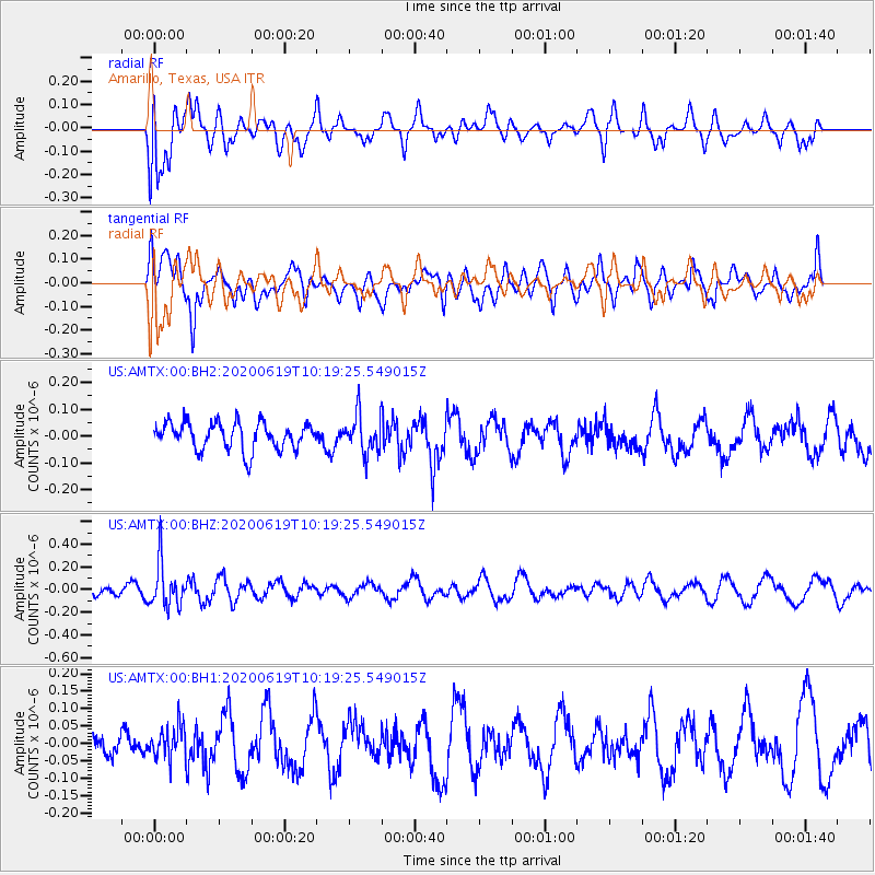
AMTX Amarillo, Texas, USA - Earthquake Result Viewer
*The percent match for this event was below the threshold and hence no stack was calculated.
| Earthquake location: |
Fiji Islands Region |
| Earthquake latitude/longitude: |
-17.5/-178.9 |
| Earthquake time(UTC): |
2020/06/19 (171) 10:07:55 GMT |
| Earthquake Depth: |
535 km |
| Earthquake Magnitude: |
5.6 Mww |
| Earthquake Catalog/Contributor: |
NEIC PDE/us |
|
| Network: |
US United States National Seismic Network |
| Station: |
AMTX Amarillo, Texas, USA |
| Lat/Lon: |
34.53 N/101.41 W |
| Elevation: |
1010 m |
|
| Distance: |
89.9 deg |
| Az: |
53.712 deg |
| Baz: |
248.738 deg |
| Ray Param: |
$rayparam |
*The percent match for this event was below the threshold and hence was not used in the summary stack. |
|
| Radial Match: |
56.34349 % |
| Radial Bump: |
400 |
| Transverse Match: |
52.512756 % |
| Transverse Bump: |
400 |
| SOD ConfigId: |
21709731 |
| Insert Time: |
2020-07-03 10:31:26.027 +0000 |
| GWidth: |
2.5 |
| Max Bumps: |
400 |
| Tol: |
0.001 |
|
Signal To Noise
| Channel | StoN | STA | LTA |
| US:AMTX:00:BHZ:20200619T10:19:25.549015Z | 2.41693 | 1.9176335E-7 | 7.934171E-8 |
| US:AMTX:00:BH1:20200619T10:19:25.549015Z | 0.63958234 | 4.6044725E-8 | 7.199187E-8 |
| US:AMTX:00:BH2:20200619T10:19:25.549015Z | 1.49109 | 7.604479E-8 | 5.099946E-8 |
| Arrivals |
| Ps | |
| PpPs | |
| PsPs/PpSs | |


