You are here: Home > Network List > US - United States National Seismic Network Stations List
> Station DGMT Dagmar, Montana, USA > Earthquake Result Viewer
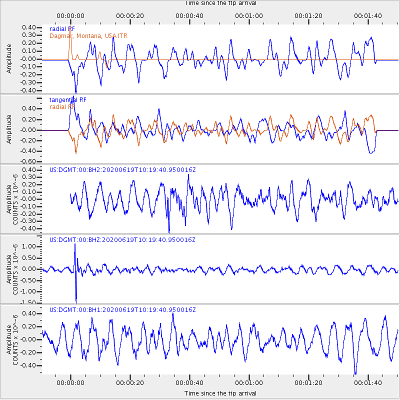
DGMT Dagmar, Montana, USA - Earthquake Result Viewer
*The percent match for this event was below the threshold and hence no stack was calculated.
| Earthquake location: |
Fiji Islands Region |
| Earthquake latitude/longitude: |
-17.5/-178.9 |
| Earthquake time(UTC): |
2020/06/19 (171) 10:07:55 GMT |
| Earthquake Depth: |
535 km |
| Earthquake Magnitude: |
5.6 Mww |
| Earthquake Catalog/Contributor: |
NEIC PDE/us |
|
| Network: |
US United States National Seismic Network |
| Station: |
DGMT Dagmar, Montana, USA |
| Lat/Lon: |
48.47 N/104.20 W |
| Elevation: |
0.0 m |
|
| Distance: |
93.2 deg |
| Az: |
40.013 deg |
| Baz: |
247.249 deg |
| Ray Param: |
$rayparam |
*The percent match for this event was below the threshold and hence was not used in the summary stack. |
|
| Radial Match: |
48.276264 % |
| Radial Bump: |
400 |
| Transverse Match: |
51.802628 % |
| Transverse Bump: |
400 |
| SOD ConfigId: |
21709731 |
| Insert Time: |
2020-07-03 10:31:31.519 +0000 |
| GWidth: |
2.5 |
| Max Bumps: |
400 |
| Tol: |
0.001 |
|
Signal To Noise
| Channel | StoN | STA | LTA |
| US:DGMT:00:BHZ:20200619T10:19:40.950016Z | 5.088787 | 4.0938764E-7 | 8.0448956E-8 |
| US:DGMT:00:BH1:20200619T10:19:40.950016Z | 1.2050737 | 1.8516253E-7 | 1.5365245E-7 |
| US:DGMT:00:BH2:20200619T10:19:40.950016Z | 1.4002596 | 1.7805056E-7 | 1.2715539E-7 |
| Arrivals |
| Ps | |
| PpPs | |
| PsPs/PpSs | |


