You are here: Home > Network List > US - United States National Seismic Network Stations List
> Station EGMT Eagleton, Montana, USA > Earthquake Result Viewer
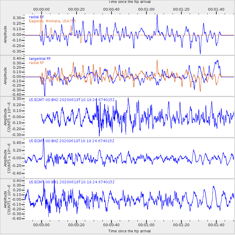
EGMT Eagleton, Montana, USA - Earthquake Result Viewer
*The percent match for this event was below the threshold and hence no stack was calculated.
| Earthquake location: |
Fiji Islands Region |
| Earthquake latitude/longitude: |
-17.5/-178.9 |
| Earthquake time(UTC): |
2020/06/19 (171) 10:07:55 GMT |
| Earthquake Depth: |
535 km |
| Earthquake Magnitude: |
5.6 Mww |
| Earthquake Catalog/Contributor: |
NEIC PDE/us |
|
| Network: |
US United States National Seismic Network |
| Station: |
EGMT Eagleton, Montana, USA |
| Lat/Lon: |
48.02 N/109.75 W |
| Elevation: |
1055 m |
|
| Distance: |
89.6 deg |
| Az: |
38.859 deg |
| Baz: |
243.14 deg |
| Ray Param: |
$rayparam |
*The percent match for this event was below the threshold and hence was not used in the summary stack. |
|
| Radial Match: |
52.834415 % |
| Radial Bump: |
400 |
| Transverse Match: |
53.837044 % |
| Transverse Bump: |
400 |
| SOD ConfigId: |
21709731 |
| Insert Time: |
2020-07-03 10:31:34.659 +0000 |
| GWidth: |
2.5 |
| Max Bumps: |
400 |
| Tol: |
0.001 |
|
Signal To Noise
| Channel | StoN | STA | LTA |
| US:EGMT:00:BHZ:20200619T10:19:24.674015Z | 3.2571867 | 1.8361665E-7 | 5.6372773E-8 |
| US:EGMT:00:BH1:20200619T10:19:24.674015Z | 1.5534889 | 1.4294591E-7 | 9.201605E-8 |
| US:EGMT:00:BH2:20200619T10:19:24.674015Z | 1.7764006 | 1.3161967E-7 | 7.4093464E-8 |
| Arrivals |
| Ps | |
| PpPs | |
| PsPs/PpSs | |


