You are here: Home > Network List > PF - Volcanologic Network of Piton de Fournaise-OVPF Stations List
> Station GPS Grandes Pentes Sud > Earthquake Result Viewer
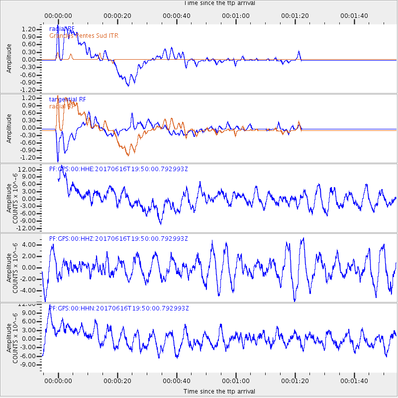
GPS Grandes Pentes Sud - Earthquake Result Viewer
*The percent match for this event was below the threshold and hence no stack was calculated.
| Earthquake location: |
Pacific-Antarctic Ridge |
| Earthquake latitude/longitude: |
-62.8/-161.1 |
| Earthquake time(UTC): |
2017/06/16 (167) 19:37:26 GMT |
| Earthquake Depth: |
10 km |
| Earthquake Magnitude: |
5.7 Mww |
| Earthquake Catalog/Contributor: |
NEIC PDE/us |
|
| Network: |
PF Volcanologic Network of Piton de Fournaise-OVPF |
| Station: |
GPS Grandes Pentes Sud |
| Lat/Lon: |
21.27 S/55.76 E |
| Elevation: |
1004 m |
|
| Distance: |
91.3 deg |
| Az: |
214.006 deg |
| Baz: |
164.021 deg |
| Ray Param: |
$rayparam |
*The percent match for this event was below the threshold and hence was not used in the summary stack. |
|
| Radial Match: |
66.48799 % |
| Radial Bump: |
400 |
| Transverse Match: |
44.282513 % |
| Transverse Bump: |
400 |
| SOD ConfigId: |
2140511 |
| Insert Time: |
2017-06-30 11:33:10.793 +0000 |
| GWidth: |
2.5 |
| Max Bumps: |
400 |
| Tol: |
0.001 |
|
Signal To Noise
| Channel | StoN | STA | LTA |
| PF:GPS:00:HHZ:20170616T19:50:00.792993Z | 0.43040204 | 1.1968664E-6 | 2.78081E-6 |
| PF:GPS:00:HHN:20170616T19:50:00.792993Z | 1.4828418 | 8.140979E-6 | 5.4901193E-6 |
| PF:GPS:00:HHE:20170616T19:50:00.792993Z | 2.3244758 | 8.121405E-6 | 3.493865E-6 |
| Arrivals |
| Ps | |
| PpPs | |
| PsPs/PpSs | |


