You are here: Home > Network List > KN - Kyrgyz Seismic Telemetry Network Stations List
> Station ULHL KN.ULHL > Earthquake Result Viewer
ULHL KN.ULHL - Earthquake Result Viewer

| Earthquake location: |
Mariana Islands |
| Earthquake latitude/longitude: |
18.9/145.2 |
| Earthquake time(UTC): |
1995/08/23 (235) 07:06:02 GMT |
| Earthquake Depth: |
596 km |
| Earthquake Magnitude: |
6.3 MB, 6.3 UNKNOWN, 7.0 MW |
| Earthquake Catalog/Contributor: |
WHDF/NEIC |
|
| Network: |
KN Kyrgyz Seismic Telemetry Network |
| Station: |
ULHL KN.ULHL |
| Lat/Lon: |
42.25 N/76.24 E |
| Elevation: |
2040 m |
|
| Distance: |
62.1 deg |
| Az: |
308.37 deg |
| Baz: |
89.31 deg |
| Ray Param: |
0.058126077 |
| Estimated Moho Depth: |
54.0 km |
| Estimated Crust Vp/Vs: |
1.95 |
| Assumed Crust Vp: |
6.306 km/s |
| Estimated Crust Vs: |
3.238 km/s |
| Estimated Crust Poisson's Ratio: |
0.32 |
|
| Radial Match: |
95.73158 % |
| Radial Bump: |
353 |
| Transverse Match: |
89.30345 % |
| Transverse Bump: |
370 |
| SOD ConfigId: |
6273 |
| Insert Time: |
2010-03-08 21:44:41.306 +0000 |
| GWidth: |
2.5 |
| Max Bumps: |
400 |
| Tol: |
0.001 |
|
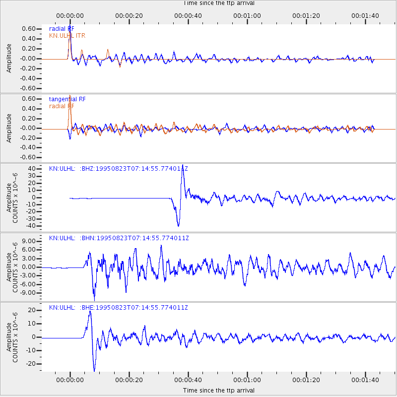
Signal To Noise
| Channel | StoN | STA | LTA |
| KN:ULHL: :BHN:19950823T07:14:55.774011Z | 3.2636228 | 1.5334868E-7 | 4.6987257E-8 |
| KN:ULHL: :BHE:19950823T07:14:55.774011Z | 6.946309 | 5.1629195E-7 | 7.432609E-8 |
| KN:ULHL: :BHZ:19950823T07:14:55.774011Z | 15.684205 | 1.1408832E-6 | 7.27409E-8 |
| Arrivals |
| Ps | 8.4 SECOND |
| PpPs | 24 SECOND |
| PsPs/PpSs | 33 SECOND |


