ULHL KN.ULHL - Earthquake Result Viewer
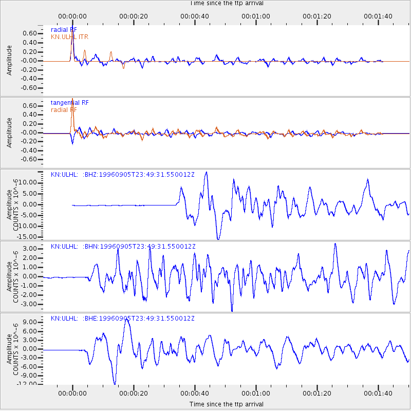
Earthquake location: Taiwan Region
Earthquake latitude/longitude: 21.9/121.5
Earthquake time(UTC): 1996/09/05 (249) 23:42:06 GMT
Earthquake Depth: 20 km
Earthquake Magnitude: 6.4 MB, 6.6 MS, 6.8 UNKNOWN, 6.8 ME
Earthquake Catalog/Contributor: WHDF/NEIC
Network: KN Kyrgyz Seismic Telemetry Network
Station: ULHL KN.ULHL
Lat/Lon: 42.25 N/76.24 E
Elevation: 2040 m
Distance: 42.8 deg
Az: 309.079 deg
Baz: 103.846 deg
Ray Param: 0.072934814
Estimated Moho Depth: 66.5 km
Estimated Crust Vp/Vs: 1.67
Assumed Crust Vp: 6.306 km/s
Estimated Crust Vs: 3.782 km/s
Estimated Crust Poisson's Ratio: 0.22
Radial Match: 95.88543 %
Radial Bump: 375
Transverse Match: 80.279335 %
Transverse Bump: 400
SOD ConfigId: 6273
Insert Time: 2010-03-08 21:45:03.044 +0000
GWidth: 2.5
Max Bumps: 400
Tol: 0.001

Signal To Noise

ChannelStoNSTALTA
KN:ULHL: :BHN:19960905T23:49:31.550012Z1.23110345.5129757E-84.4780766E-8
KN:ULHL: :BHE:19960905T23:49:31.550012Z3.26367523.153892E-79.663621E-8
KN:ULHL: :BHZ:19960905T23:49:31.550012Z7.1120375.1238794E-77.2045175E-8
Arrivals
Ps7.5 SECOND
PpPs26 SECOND
PsPs/PpSs34 SECOND