You are here: Home > Network List > OH - Ohio Seismic Network Stations List
> Station P51A Williamsport, OH, USA > Earthquake Result Viewer
P51A Williamsport, OH, USA - Earthquake Result Viewer
| Earthquake location: |
Iceland Region |
| Earthquake latitude/longitude: |
66.5/-18.4 |
| Earthquake time(UTC): |
2020/06/20 (172) 15:05:11 GMT |
| Earthquake Depth: |
10 km |
| Earthquake Magnitude: |
5.4 Mww |
| Earthquake Catalog/Contributor: |
NEIC PDE/us |
|
| Network: |
OH Ohio Seismic Network |
| Station: |
P51A Williamsport, OH, USA |
| Lat/Lon: |
39.48 N/83.06 W |
| Elevation: |
211 m |
|
| Distance: |
44.5 deg |
| Az: |
266.009 deg |
| Baz: |
31.166 deg |
| Ray Param: |
0.07187307 |
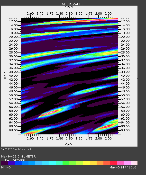
| Estimated Moho Depth: |
59.0 km |
| Estimated Crust Vp/Vs: |
1.74 |
| Assumed Crust Vp: |
6.232 km/s |
| Estimated Crust Vs: |
3.576 km/s |
| Estimated Crust Poisson's Ratio: |
0.25 |
|
| Radial Match: |
87.99024 % |
| Radial Bump: |
357 |
| Transverse Match: |
63.34486 % |
| Transverse Bump: |
400 |
| SOD ConfigId: |
21709731 |
| Insert Time: |
2020-07-04 15:26:00.508 +0000 |
| GWidth: |
2.5 |
| Max Bumps: |
400 |
| Tol: |
0.001 |
|

Signal To Noise
| Channel | StoN | STA | LTA |
| OH:P51A: :HHZ:20200620T15:12:52.178991Z | 10.563472 | 6.5846774E-7 | 6.233441E-8 |
| OH:P51A: :HHN:20200620T15:12:52.178991Z | 5.9600577 | 4.2794056E-7 | 7.180141E-8 |
| OH:P51A: :HHE:20200620T15:12:52.178991Z | 3.5153518 | 2.692603E-7 | 7.6595555E-8 |
| Arrivals |
| Ps | 7.5 SECOND |
| PpPs | 24 SECOND |
| PsPs/PpSs | 32 SECOND |


