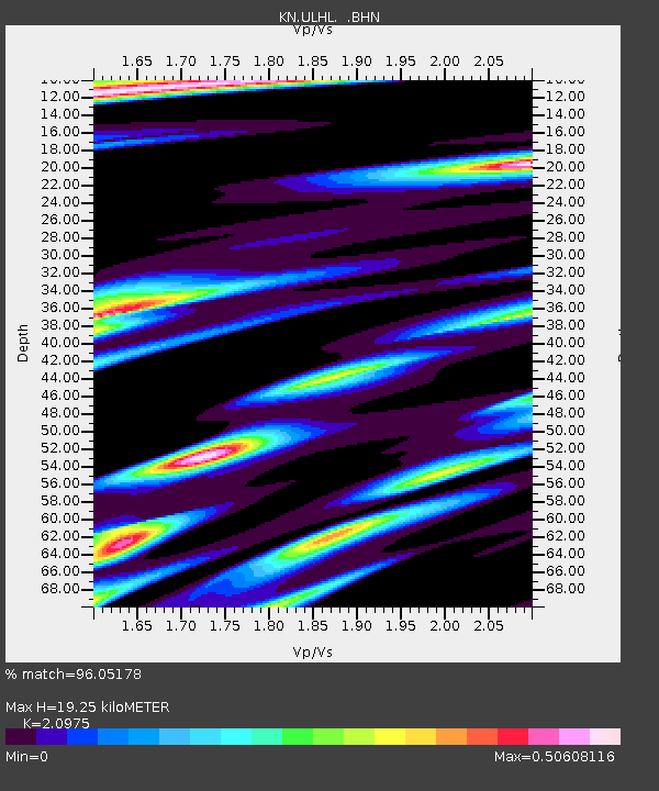
ULHL KN.ULHL - Earthquake Result Viewer

Earthquake location: Southwest Of Sumatra, Indonesia
Earthquake latitude/longitude: -0.2/97.7
Earthquake time(UTC): 2005/04/08 (098) 05:48:37 GMT
Earthquake Depth: 21 km
Earthquake Magnitude: 5.7 MB, 6.3 MS, 6.1 MW, 6.1 MW
Earthquake Catalog/Contributor: WHDF/NEIC
Network: KN Kyrgyz Seismic Telemetry Network
Station: ULHL KN.ULHL
Lat/Lon: 42.25 N/76.24 E
Elevation: 2040 m
Distance: 46.5 deg
Az: 337.976 deg
Baz: 149.666 deg
Ray Param: 0.07058008
Estimated Moho Depth: 19.25 km
Estimated Crust Vp/Vs: 2.10
Assumed Crust Vp: 6.306 km/s
Estimated Crust Vs: 3.006 km/s
Estimated Crust Poisson's Ratio: 0.35
Radial Match: 96.05178 %
Radial Bump: 292
Transverse Match: 83.97962 %
Transverse Bump: 400
SOD ConfigId: 2459
Insert Time: 2010-03-08 21:47:27.084 +0000
GWidth: 2.5
Max Bumps: 400
Tol: 0.001

Signal To Noise

ChannelStoNSTALTA
KN:ULHL: :BHN:20050408T05:56:32.700007Z2.88970331.3600994E-74.70671E-8
KN:ULHL: :BHE:20050408T05:56:32.700007Z1.86790191.209482E-76.475083E-8
KN:ULHL: :BHZ:20050408T05:56:32.700007Z5.51720242.8637265E-75.190541E-8
Arrivals
Ps3.5 SECOND
PpPs9.0 SECOND
PsPs/PpSs13 SECOND