You are here: Home > Network List > TA - USArray Transportable Network (new EarthScope stations) Stations List
> Station E27K Coleen River, AK, USA > Earthquake Result Viewer
E27K Coleen River, AK, USA - Earthquake Result Viewer
| Earthquake location: |
Iceland Region |
| Earthquake latitude/longitude: |
66.5/-18.4 |
| Earthquake time(UTC): |
2020/06/20 (172) 15:05:11 GMT |
| Earthquake Depth: |
10 km |
| Earthquake Magnitude: |
5.4 Mww |
| Earthquake Catalog/Contributor: |
NEIC PDE/us |
|
| Network: |
TA USArray Transportable Network (new EarthScope stations) |
| Station: |
E27K Coleen River, AK, USA |
| Lat/Lon: |
68.19 N/141.60 W |
| Elevation: |
654 m |
|
| Distance: |
39.9 deg |
| Az: |
330.821 deg |
| Baz: |
31.582 deg |
| Ray Param: |
0.07471855 |
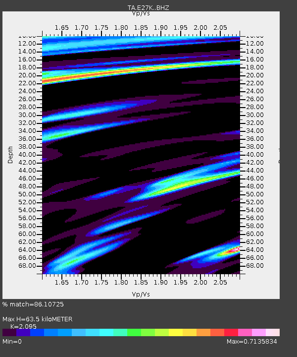
| Estimated Moho Depth: |
63.5 km |
| Estimated Crust Vp/Vs: |
2.10 |
| Assumed Crust Vp: |
6.522 km/s |
| Estimated Crust Vs: |
3.113 km/s |
| Estimated Crust Poisson's Ratio: |
0.35 |
|
| Radial Match: |
86.10725 % |
| Radial Bump: |
400 |
| Transverse Match: |
70.404175 % |
| Transverse Bump: |
400 |
| SOD ConfigId: |
21709731 |
| Insert Time: |
2020-07-04 15:29:04.784 +0000 |
| GWidth: |
2.5 |
| Max Bumps: |
400 |
| Tol: |
0.001 |
|

Signal To Noise
| Channel | StoN | STA | LTA |
| TA:E27K: :BHZ:20200620T15:12:14.400Z | 1.6652275 | 1.13924585E-7 | 6.8413826E-8 |
| TA:E27K: :BHN:20200620T15:12:14.400Z | 1.566585 | 5.2231126E-8 | 3.3340754E-8 |
| TA:E27K: :BHE:20200620T15:12:14.400Z | 1.0087463 | 3.4814278E-8 | 3.4512425E-8 |
| Arrivals |
| Ps | 11 SECOND |
| PpPs | 28 SECOND |
| PsPs/PpSs | 40 SECOND |


