You are here: Home > Network List > TA - USArray Transportable Network (new EarthScope stations) Stations List
> Station E29M Blow River, YT, CAN > Earthquake Result Viewer
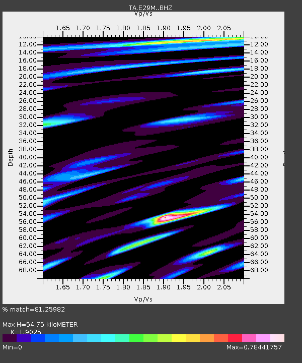
E29M Blow River, YT, CAN - Earthquake Result Viewer
| Earthquake location: |
Iceland Region |
| Earthquake latitude/longitude: |
66.5/-18.4 |
| Earthquake time(UTC): |
2020/06/20 (172) 15:05:11 GMT |
| Earthquake Depth: |
10 km |
| Earthquake Magnitude: |
5.4 Mww |
| Earthquake Catalog/Contributor: |
NEIC PDE/us |
|
| Network: |
TA USArray Transportable Network (new EarthScope stations) |
| Station: |
E29M Blow River, YT, CAN |
| Lat/Lon: |
68.39 N/137.90 W |
| Elevation: |
324 m |
|
| Distance: |
39.0 deg |
| Az: |
329.171 deg |
| Baz: |
33.74 deg |
| Ray Param: |
0.07527671 |
| Estimated Moho Depth: |
54.75 km |
| Estimated Crust Vp/Vs: |
1.90 |
| Assumed Crust Vp: |
5.981 km/s |
| Estimated Crust Vs: |
3.144 km/s |
| Estimated Crust Poisson's Ratio: |
0.31 |
|
| Radial Match: |
81.25982 % |
| Radial Bump: |
400 |
| Transverse Match: |
66.03386 % |
| Transverse Bump: |
400 |
| SOD ConfigId: |
21709731 |
| Insert Time: |
2020-07-04 15:29:05.633 +0000 |
| GWidth: |
2.5 |
| Max Bumps: |
400 |
| Tol: |
0.001 |
|

Signal To Noise
| Channel | StoN | STA | LTA |
| TA:E29M: :BHZ:20200620T15:12:06.775Z | 1.9387802 | 1.21876E-7 | 6.28622E-8 |
| TA:E29M: :BHN:20200620T15:12:06.775Z | 3.1527832 | 9.305206E-8 | 2.951426E-8 |
| TA:E29M: :BHE:20200620T15:12:06.775Z | 1.204817 | 4.418589E-8 | 3.6674354E-8 |
| Arrivals |
| Ps | 8.7 SECOND |
| PpPs | 25 SECOND |
| PsPs/PpSs | 34 SECOND |


