You are here: Home > Network List > TA - USArray Transportable Network (new EarthScope stations) Stations List
> Station G30M túh Zraii Njik, YT, CAN > Earthquake Result Viewer
G30M túh Zraii Njik, YT, CAN - Earthquake Result Viewer
| Earthquake location: |
Iceland Region |
| Earthquake latitude/longitude: |
66.5/-18.4 |
| Earthquake time(UTC): |
2020/06/20 (172) 15:05:11 GMT |
| Earthquake Depth: |
10 km |
| Earthquake Magnitude: |
5.4 Mww |
| Earthquake Catalog/Contributor: |
NEIC PDE/us |
|
| Network: |
TA USArray Transportable Network (new EarthScope stations) |
| Station: |
G30M túh Zraii Njik, YT, CAN |
| Lat/Lon: |
66.98 N/136.22 W |
| Elevation: |
739 m |
|
| Distance: |
39.8 deg |
| Az: |
327.094 deg |
| Baz: |
33.684 deg |
| Ray Param: |
0.07477508 |
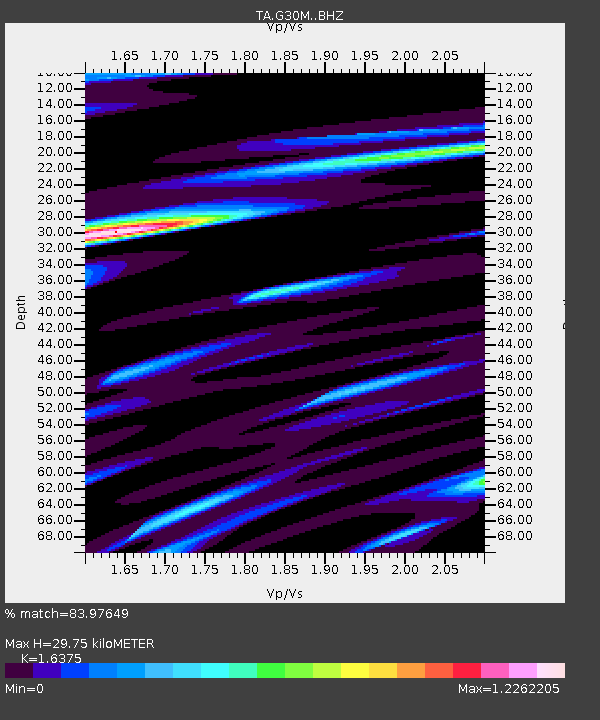
| Estimated Moho Depth: |
29.75 km |
| Estimated Crust Vp/Vs: |
1.64 |
| Assumed Crust Vp: |
6.522 km/s |
| Estimated Crust Vs: |
3.983 km/s |
| Estimated Crust Poisson's Ratio: |
0.20 |
|
| Radial Match: |
83.97649 % |
| Radial Bump: |
390 |
| Transverse Match: |
58.894802 % |
| Transverse Bump: |
400 |
| SOD ConfigId: |
21709731 |
| Insert Time: |
2020-07-04 15:29:24.979 +0000 |
| GWidth: |
2.5 |
| Max Bumps: |
400 |
| Tol: |
0.001 |
|

Signal To Noise
| Channel | StoN | STA | LTA |
| TA:G30M: :BHZ:20200620T15:12:13.625006Z | 3.2683885 | 1.9584594E-7 | 5.9921256E-8 |
| TA:G30M: :BHN:20200620T15:12:13.625006Z | 1.6364834 | 8.8960356E-8 | 5.436068E-8 |
| TA:G30M: :BHE:20200620T15:12:13.625006Z | 0.85223734 | 4.9725283E-8 | 5.8346757E-8 |
| Arrivals |
| Ps | 3.1 SECOND |
| PpPs | 11 SECOND |
| PsPs/PpSs | 14 SECOND |


