You are here: Home > Network List > G - GEOSCOPE Stations List
> Station TAOE Taiohae, Marquises islands > Earthquake Result Viewer
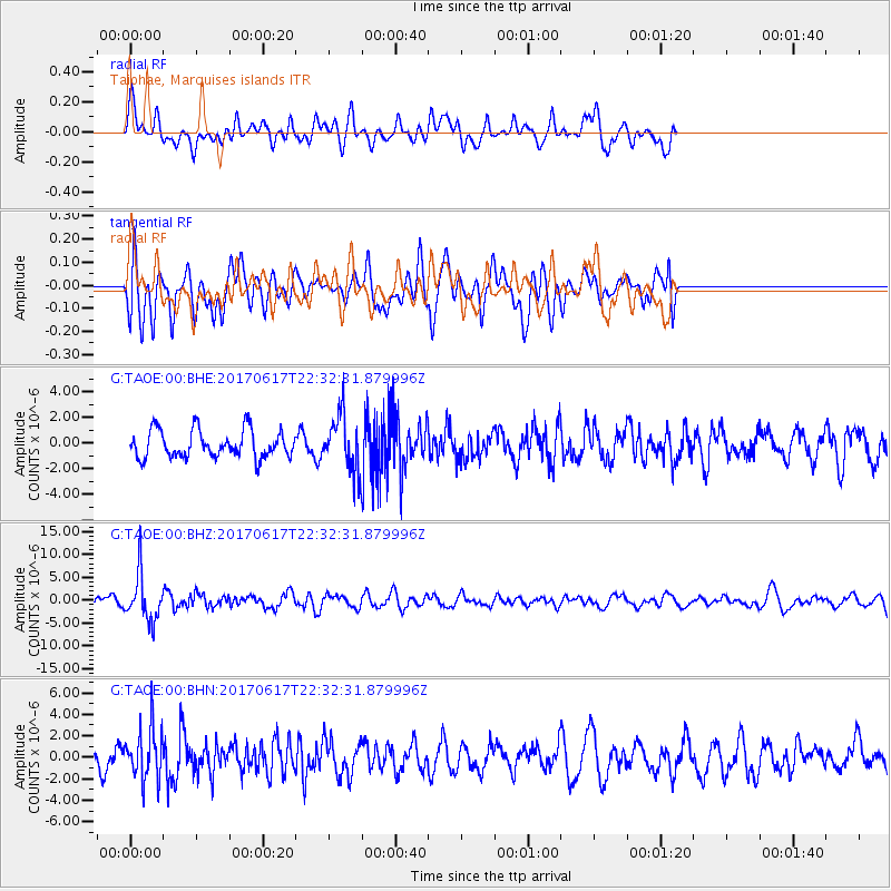
TAOE Taiohae, Marquises islands - Earthquake Result Viewer
*The percent match for this event was below the threshold and hence no stack was calculated.
| Earthquake location: |
South Of Fiji Islands |
| Earthquake latitude/longitude: |
-24.1/179.6 |
| Earthquake time(UTC): |
2017/06/17 (168) 22:26:02 GMT |
| Earthquake Depth: |
518 km |
| Earthquake Magnitude: |
6.1 Mww |
| Earthquake Catalog/Contributor: |
NEIC PDE/us |
|
| Network: |
G GEOSCOPE |
| Station: |
TAOE Taiohae, Marquises islands |
| Lat/Lon: |
8.85 S/140.15 W |
| Elevation: |
800 m |
|
| Distance: |
41.3 deg |
| Az: |
75.386 deg |
| Baz: |
243.48 deg |
| Ray Param: |
$rayparam |
*The percent match for this event was below the threshold and hence was not used in the summary stack. |
|
| Radial Match: |
66.131355 % |
| Radial Bump: |
400 |
| Transverse Match: |
58.645157 % |
| Transverse Bump: |
400 |
| SOD ConfigId: |
2140511 |
| Insert Time: |
2017-07-01 14:20:19.293 +0000 |
| GWidth: |
2.5 |
| Max Bumps: |
400 |
| Tol: |
0.001 |
|
Signal To Noise
| Channel | StoN | STA | LTA |
| G:TAOE:00:BHZ:20170617T22:32:31.879996Z | 5.3962665 | 5.026929E-6 | 9.315568E-7 |
| G:TAOE:00:BHN:20170617T22:32:31.879996Z | 2.1709855 | 2.4019498E-6 | 1.1063869E-6 |
| G:TAOE:00:BHE:20170617T22:32:31.879996Z | 2.0191395 | 2.1586716E-6 | 1.0691048E-6 |
| Arrivals |
| Ps | |
| PpPs | |
| PsPs/PpSs | |


