You are here: Home > Network List > II - Global Seismograph Network (GSN - IRIS/IDA) Stations List
> Station WRAB Tennant Creek, NT, Australia > Earthquake Result Viewer
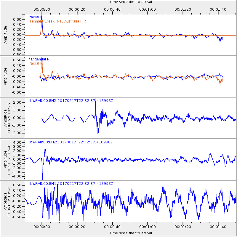
WRAB Tennant Creek, NT, Australia - Earthquake Result Viewer
*The percent match for this event was below the threshold and hence no stack was calculated.
| Earthquake location: |
South Of Fiji Islands |
| Earthquake latitude/longitude: |
-24.1/179.6 |
| Earthquake time(UTC): |
2017/06/17 (168) 22:26:02 GMT |
| Earthquake Depth: |
518 km |
| Earthquake Magnitude: |
6.1 Mww |
| Earthquake Catalog/Contributor: |
NEIC PDE/us |
|
| Network: |
II Global Seismograph Network (GSN - IRIS/IDA) |
| Station: |
WRAB Tennant Creek, NT, Australia |
| Lat/Lon: |
19.93 S/134.36 E |
| Elevation: |
366 m |
|
| Distance: |
42.0 deg |
| Az: |
266.52 deg |
| Baz: |
104.185 deg |
| Ray Param: |
$rayparam |
*The percent match for this event was below the threshold and hence was not used in the summary stack. |
|
| Radial Match: |
68.694695 % |
| Radial Bump: |
400 |
| Transverse Match: |
73.6922 % |
| Transverse Bump: |
400 |
| SOD ConfigId: |
2140511 |
| Insert Time: |
2017-07-01 14:21:26.613 +0000 |
| GWidth: |
2.5 |
| Max Bumps: |
400 |
| Tol: |
0.001 |
|
Signal To Noise
| Channel | StoN | STA | LTA |
| II:WRAB:00:BHZ:20170617T22:32:37.418998Z | 3.0695593 | 1.3586648E-6 | 4.4262535E-7 |
| II:WRAB:00:BH1:20170617T22:32:37.418998Z | 1.4789948 | 2.986026E-7 | 2.0189563E-7 |
| II:WRAB:00:BH2:20170617T22:32:37.418998Z | 3.2340245 | 9.62909E-7 | 2.9774324E-7 |
| Arrivals |
| Ps | |
| PpPs | |
| PsPs/PpSs | |


