You are here: Home > Network List > KN - Kyrgyz Seismic Telemetry Network Stations List
> Station ULHL KN.ULHL > Earthquake Result Viewer
ULHL KN.ULHL - Earthquake Result Viewer
| Earthquake location: |
Southern Sumatra, Indonesia |
| Earthquake latitude/longitude: |
-0.7/99.9 |
| Earthquake time(UTC): |
2009/09/30 (273) 10:16:09 GMT |
| Earthquake Depth: |
81 km |
| Earthquake Magnitude: |
7.1 MB, 7.5 MW, 7.5 MW |
| Earthquake Catalog/Contributor: |
WHDF/NEIC |
|
| Network: |
KN Kyrgyz Seismic Telemetry Network |
| Station: |
ULHL KN.ULHL |
| Lat/Lon: |
42.25 N/76.24 E |
| Elevation: |
2040 m |
|
| Distance: |
47.8 deg |
| Az: |
336.312 deg |
| Baz: |
147.247 deg |
| Ray Param: |
0.06952229 |
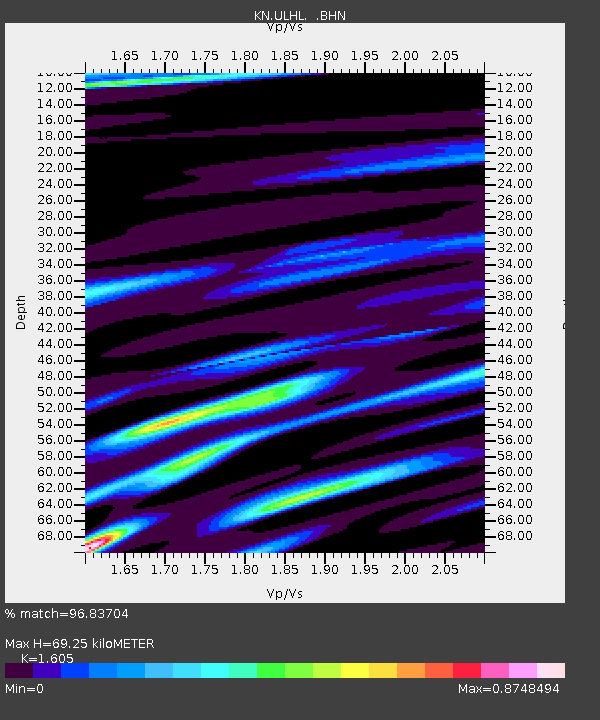
| Estimated Moho Depth: |
69.25 km |
| Estimated Crust Vp/Vs: |
1.61 |
| Assumed Crust Vp: |
6.306 km/s |
| Estimated Crust Vs: |
3.929 km/s |
| Estimated Crust Poisson's Ratio: |
0.18 |
|
| Radial Match: |
96.83704 % |
| Radial Bump: |
388 |
| Transverse Match: |
89.68881 % |
| Transverse Bump: |
400 |
| SOD ConfigId: |
2622 |
| Insert Time: |
2010-03-08 21:50:12.954 +0000 |
| GWidth: |
2.5 |
| Max Bumps: |
400 |
| Tol: |
0.001 |
|

Signal To Noise
| Channel | StoN | STA | LTA |
| KN:ULHL: :BHN:20090930T10:24:07.924011Z | 124.55605 | 2.0216581E-5 | 1.6230909E-7 |
| KN:ULHL: :BHE:20090930T10:24:07.924011Z | 73.045876 | 6.6797425E-6 | 9.144585E-8 |
| KN:ULHL: :BHZ:20090930T10:24:07.924011Z | 64.335594 | 7.633873E-6 | 1.1865707E-7 |
| Arrivals |
| Ps | 7.1 SECOND |
| PpPs | 27 SECOND |
| PsPs/PpSs | 34 SECOND |


