You are here: Home > Network List > IU - Global Seismograph Network (GSN - IRIS/USGS) Stations List
> Station CTAO Charters Towers, Australia > Earthquake Result Viewer
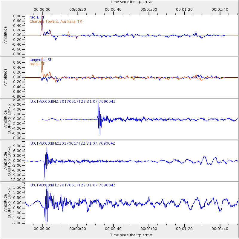
CTAO Charters Towers, Australia - Earthquake Result Viewer
*The percent match for this event was below the threshold and hence no stack was calculated.
| Earthquake location: |
South Of Fiji Islands |
| Earthquake latitude/longitude: |
-24.1/179.6 |
| Earthquake time(UTC): |
2017/06/17 (168) 22:26:02 GMT |
| Earthquake Depth: |
518 km |
| Earthquake Magnitude: |
6.1 Mww |
| Earthquake Catalog/Contributor: |
NEIC PDE/us |
|
| Network: |
IU Global Seismograph Network (GSN - IRIS/USGS) |
| Station: |
CTAO Charters Towers, Australia |
| Lat/Lon: |
20.09 S/146.25 E |
| Elevation: |
357 m |
|
| Distance: |
31.1 deg |
| Az: |
270.766 deg |
| Baz: |
103.552 deg |
| Ray Param: |
$rayparam |
*The percent match for this event was below the threshold and hence was not used in the summary stack. |
|
| Radial Match: |
78.11175 % |
| Radial Bump: |
360 |
| Transverse Match: |
68.53294 % |
| Transverse Bump: |
400 |
| SOD ConfigId: |
2140511 |
| Insert Time: |
2017-07-01 14:21:43.095 +0000 |
| GWidth: |
2.5 |
| Max Bumps: |
400 |
| Tol: |
0.001 |
|
Signal To Noise
| Channel | StoN | STA | LTA |
| IU:CTAO:00:BHZ:20170617T22:31:07.769004Z | 16.940784 | 3.0698202E-6 | 1.8120886E-7 |
| IU:CTAO:00:BH1:20170617T22:31:07.769004Z | 3.065956 | 7.7023486E-7 | 2.5122176E-7 |
| IU:CTAO:00:BH2:20170617T22:31:07.769004Z | 12.994854 | 2.199261E-6 | 1.6924092E-7 |
| Arrivals |
| Ps | |
| PpPs | |
| PsPs/PpSs | |


