You are here: Home > Network List > TA - USArray Transportable Network (new EarthScope stations) Stations List
> Station F20K Avaraart Lake, AK, USA > Earthquake Result Viewer
F20K Avaraart Lake, AK, USA - Earthquake Result Viewer
| Earthquake location: |
Iceland Region |
| Earthquake latitude/longitude: |
66.3/-18.9 |
| Earthquake time(UTC): |
2020/06/20 (172) 19:26:21 GMT |
| Earthquake Depth: |
10 km |
| Earthquake Magnitude: |
5.7 mww |
| Earthquake Catalog/Contributor: |
NEIC PDE/us |
|
| Network: |
TA USArray Transportable Network (new EarthScope stations) |
| Station: |
F20K Avaraart Lake, AK, USA |
| Lat/Lon: |
67.05 N/155.73 W |
| Elevation: |
136 m |
|
| Distance: |
43.5 deg |
| Az: |
337.049 deg |
| Baz: |
23.711 deg |
| Ray Param: |
0.07252742 |
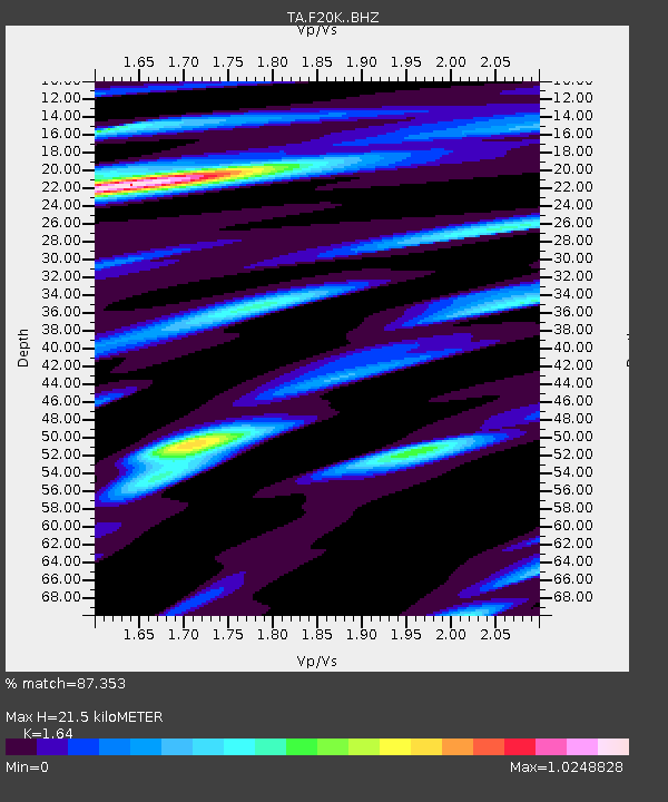
| Estimated Moho Depth: |
21.5 km |
| Estimated Crust Vp/Vs: |
1.64 |
| Assumed Crust Vp: |
6.522 km/s |
| Estimated Crust Vs: |
3.977 km/s |
| Estimated Crust Poisson's Ratio: |
0.20 |
|
| Radial Match: |
87.353 % |
| Radial Bump: |
400 |
| Transverse Match: |
69.76397 % |
| Transverse Bump: |
400 |
| SOD ConfigId: |
21709731 |
| Insert Time: |
2020-07-04 19:44:24.717 +0000 |
| GWidth: |
2.5 |
| Max Bumps: |
400 |
| Tol: |
0.001 |
|
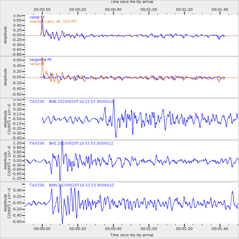
Signal To Noise
| Channel | StoN | STA | LTA |
| TA:F20K: :BHZ:20200620T19:33:53.800001Z | 2.4394848 | 1.2406305E-7 | 5.085625E-8 |
| TA:F20K: :BHN:20200620T19:33:53.800001Z | 1.579556 | 6.289452E-8 | 3.981785E-8 |
| TA:F20K: :BHE:20200620T19:33:53.800001Z | 0.850614 | 3.508193E-8 | 4.1243066E-8 |
| Arrivals |
| Ps | 2.3 SECOND |
| PpPs | 8.1 SECOND |
| PsPs/PpSs | 10 SECOND |


