You are here: Home > Network List > TA - USArray Transportable Network (new EarthScope stations) Stations List
> Station F26K Sheenjek River, AK, USA > Earthquake Result Viewer
F26K Sheenjek River, AK, USA - Earthquake Result Viewer
| Earthquake location: |
Iceland Region |
| Earthquake latitude/longitude: |
66.3/-18.9 |
| Earthquake time(UTC): |
2020/06/20 (172) 19:26:21 GMT |
| Earthquake Depth: |
10 km |
| Earthquake Magnitude: |
5.7 mww |
| Earthquake Catalog/Contributor: |
NEIC PDE/us |
|
| Network: |
TA USArray Transportable Network (new EarthScope stations) |
| Station: |
F26K Sheenjek River, AK, USA |
| Lat/Lon: |
67.69 N/144.15 W |
| Elevation: |
683 m |
|
| Distance: |
40.9 deg |
| Az: |
331.548 deg |
| Baz: |
30.314 deg |
| Ray Param: |
0.074146174 |
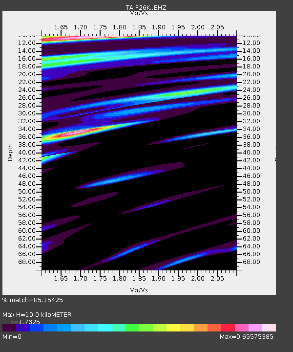
| Estimated Moho Depth: |
10.0 km |
| Estimated Crust Vp/Vs: |
1.76 |
| Assumed Crust Vp: |
6.522 km/s |
| Estimated Crust Vs: |
3.7 km/s |
| Estimated Crust Poisson's Ratio: |
0.26 |
|
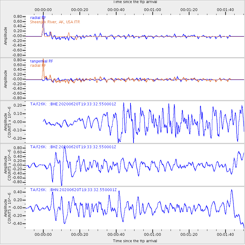
| Radial Match: |
85.15425 % |
| Radial Bump: |
400 |
| Transverse Match: |
64.67869 % |
| Transverse Bump: |
400 |
| SOD ConfigId: |
21709731 |
| Insert Time: |
2020-07-04 19:44:28.696 +0000 |
| GWidth: |
2.5 |
| Max Bumps: |
400 |
| Tol: |
0.001 |
|
Signal To Noise
| Channel | StoN | STA | LTA |
| TA:F26K: :BHZ:20200620T19:33:32.550001Z | 1.8103086 | 1.3327383E-7 | 7.36194E-8 |
| TA:F26K: :BHN:20200620T19:33:32.550001Z | 2.380254 | 7.863508E-8 | 3.3036425E-8 |
| TA:F26K: :BHE:20200620T19:33:32.550001Z | 2.4632032 | 7.460651E-8 | 3.0288412E-8 |
| Arrivals |
| Ps | 1.3 SECOND |
| PpPs | 3.9 SECOND |
| PsPs/PpSs | 5.2 SECOND |


