You are here: Home > Network List > TA - USArray Transportable Network (new EarthScope stations) Stations List
> Station G31M Satah River, YT, CAN > Earthquake Result Viewer
G31M Satah River, YT, CAN - Earthquake Result Viewer
| Earthquake location: |
Iceland Region |
| Earthquake latitude/longitude: |
66.3/-18.9 |
| Earthquake time(UTC): |
2020/06/20 (172) 19:26:21 GMT |
| Earthquake Depth: |
10 km |
| Earthquake Magnitude: |
5.7 mww |
| Earthquake Catalog/Contributor: |
NEIC PDE/us |
|
| Network: |
TA USArray Transportable Network (new EarthScope stations) |
| Station: |
G31M Satah River, YT, CAN |
| Lat/Lon: |
66.92 N/134.27 W |
| Elevation: |
61 m |
|
| Distance: |
39.4 deg |
| Az: |
325.906 deg |
| Baz: |
35.105 deg |
| Ray Param: |
0.07498805 |
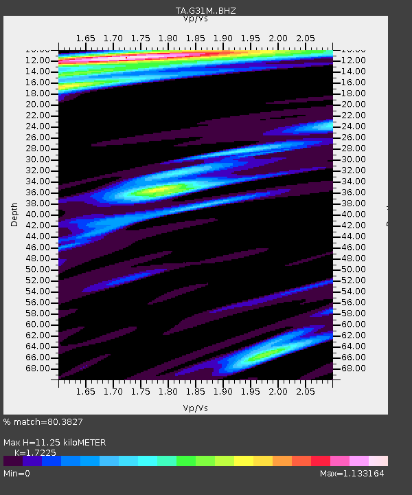
| Estimated Moho Depth: |
11.25 km |
| Estimated Crust Vp/Vs: |
1.72 |
| Assumed Crust Vp: |
6.171 km/s |
| Estimated Crust Vs: |
3.583 km/s |
| Estimated Crust Poisson's Ratio: |
0.25 |
|
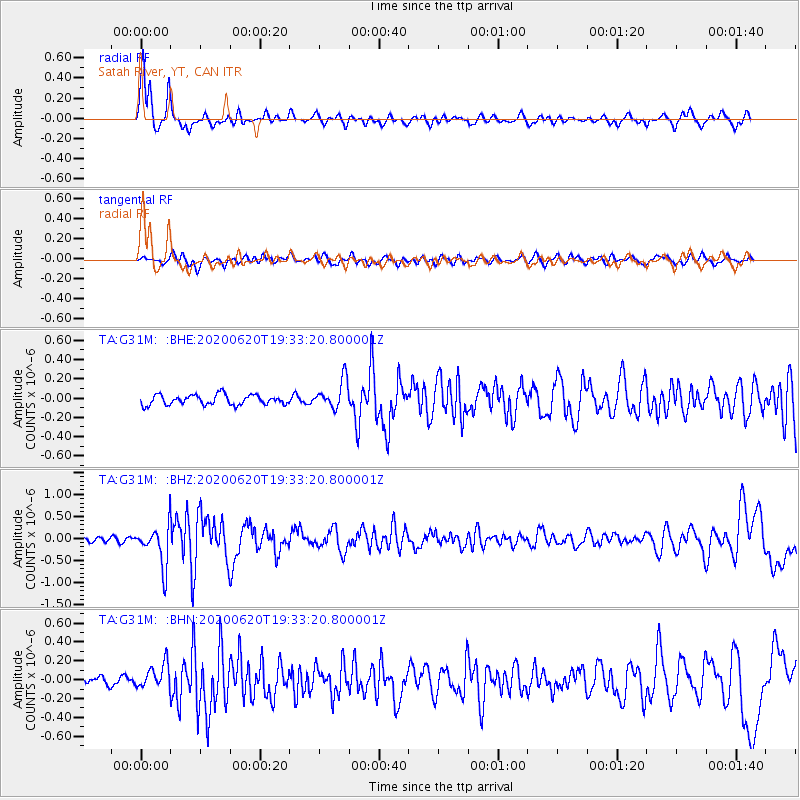
| Radial Match: |
80.3827 % |
| Radial Bump: |
351 |
| Transverse Match: |
55.62358 % |
| Transverse Bump: |
400 |
| SOD ConfigId: |
21709731 |
| Insert Time: |
2020-07-04 19:44:41.398 +0000 |
| GWidth: |
2.5 |
| Max Bumps: |
400 |
| Tol: |
0.001 |
|
Signal To Noise
| Channel | StoN | STA | LTA |
| TA:G31M: :BHZ:20200620T19:33:20.800001Z | 10.543437 | 4.6164814E-7 | 4.3785356E-8 |
| TA:G31M: :BHN:20200620T19:33:20.800001Z | 2.3436112 | 1.2806287E-7 | 5.4643394E-8 |
| TA:G31M: :BHE:20200620T19:33:20.800001Z | 2.8546236 | 1.4735491E-7 | 5.1619736E-8 |
| Arrivals |
| Ps | 1.4 SECOND |
| PpPs | 4.6 SECOND |
| PsPs/PpSs | 6.0 SECOND |


