You are here: Home > Network List > TA - USArray Transportable Network (new EarthScope stations) Stations List
> Station H31M Peel River, Yukon, CAN > Earthquake Result Viewer
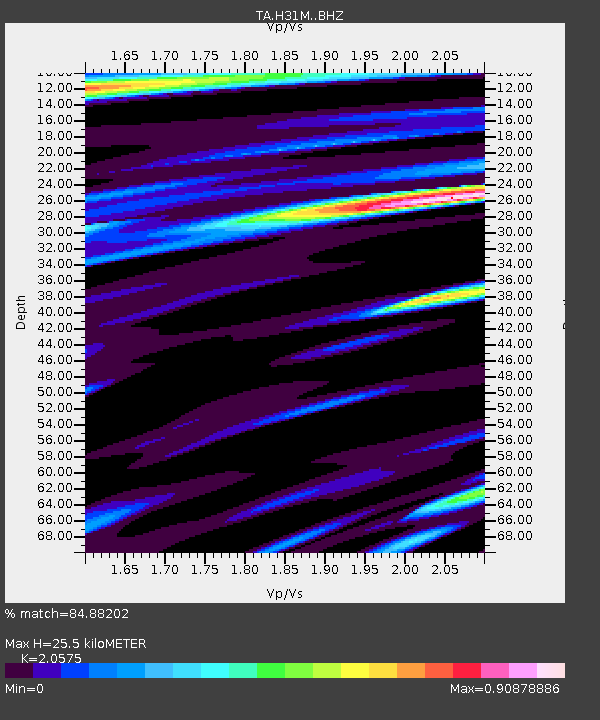
H31M Peel River, Yukon, CAN - Earthquake Result Viewer
| Earthquake location: |
Iceland Region |
| Earthquake latitude/longitude: |
66.3/-18.9 |
| Earthquake time(UTC): |
2020/06/20 (172) 19:26:21 GMT |
| Earthquake Depth: |
10 km |
| Earthquake Magnitude: |
5.7 mww |
| Earthquake Catalog/Contributor: |
NEIC PDE/us |
|
| Network: |
TA USArray Transportable Network (new EarthScope stations) |
| Station: |
H31M Peel River, Yukon, CAN |
| Lat/Lon: |
65.81 N/134.34 W |
| Elevation: |
642 m |
|
| Distance: |
40.4 deg |
| Az: |
324.947 deg |
| Baz: |
34.304 deg |
| Ray Param: |
0.07443124 |
| Estimated Moho Depth: |
25.5 km |
| Estimated Crust Vp/Vs: |
2.06 |
| Assumed Crust Vp: |
6.419 km/s |
| Estimated Crust Vs: |
3.12 km/s |
| Estimated Crust Poisson's Ratio: |
0.35 |
|
| Radial Match: |
84.88202 % |
| Radial Bump: |
400 |
| Transverse Match: |
74.892525 % |
| Transverse Bump: |
400 |
| SOD ConfigId: |
21709731 |
| Insert Time: |
2020-07-04 19:44:48.260 +0000 |
| GWidth: |
2.5 |
| Max Bumps: |
400 |
| Tol: |
0.001 |
|

Signal To Noise
| Channel | StoN | STA | LTA |
| TA:H31M: :BHZ:20200620T19:33:28.574995Z | 4.50439 | 3.5914945E-7 | 7.973321E-8 |
| TA:H31M: :BHN:20200620T19:33:28.574995Z | 2.9160326 | 1.493211E-7 | 5.120694E-8 |
| TA:H31M: :BHE:20200620T19:33:28.574995Z | 1.3945445 | 8.808755E-8 | 6.316583E-8 |
| Arrivals |
| Ps | 4.5 SECOND |
| PpPs | 11 SECOND |
| PsPs/PpSs | 16 SECOND |


