You are here: Home > Network List > TX - Texas Seismological Network Stations List
> Station FW14 Alvarado > Earthquake Result Viewer
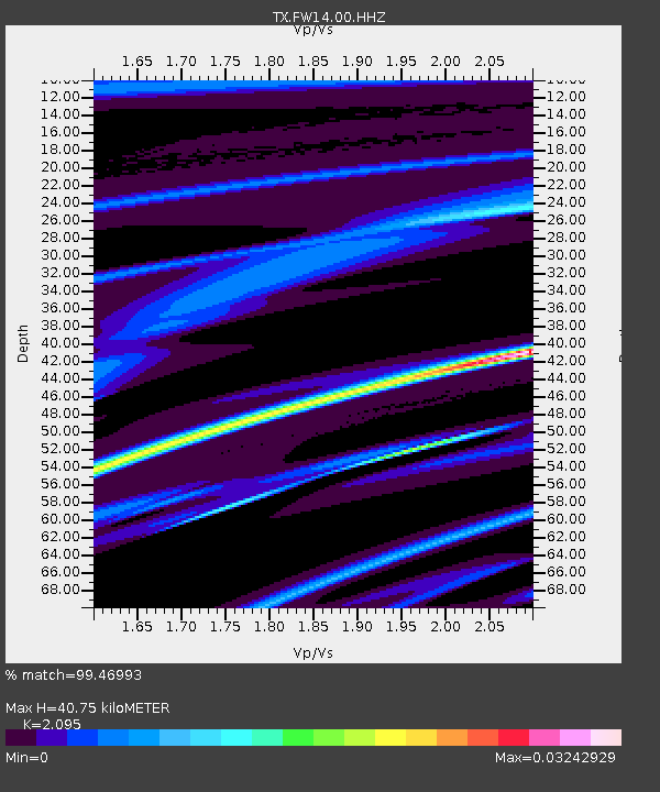
FW14 Alvarado - Earthquake Result Viewer
| Earthquake location: |
Iceland Region |
| Earthquake latitude/longitude: |
66.3/-18.9 |
| Earthquake time(UTC): |
2020/06/20 (172) 19:26:21 GMT |
| Earthquake Depth: |
10 km |
| Earthquake Magnitude: |
5.7 mww |
| Earthquake Catalog/Contributor: |
NEIC PDE/us |
|
| Network: |
TX Texas Seismological Network |
| Station: |
FW14 Alvarado |
| Lat/Lon: |
32.40 N/97.19 W |
| Elevation: |
219 m |
|
| Distance: |
56.1 deg |
| Az: |
274.056 deg |
| Baz: |
28.481 deg |
| Ray Param: |
0.06434373 |
| Estimated Moho Depth: |
40.75 km |
| Estimated Crust Vp/Vs: |
2.10 |
| Assumed Crust Vp: |
6.38 km/s |
| Estimated Crust Vs: |
3.046 km/s |
| Estimated Crust Poisson's Ratio: |
0.35 |
|
| Radial Match: |
99.46993 % |
| Radial Bump: |
34 |
| Transverse Match: |
94.27899 % |
| Transverse Bump: |
144 |
| SOD ConfigId: |
21709731 |
| Insert Time: |
2020-07-04 19:46:08.710 +0000 |
| GWidth: |
2.5 |
| Max Bumps: |
400 |
| Tol: |
0.001 |
|

Signal To Noise
| Channel | StoN | STA | LTA |
| TX:FW14:00:HHZ:20200620T19:35:29.990003Z | 1.7809677 | 2.9106093E-6 | 1.6342852E-6 |
| TX:FW14:00:HH1:20200620T19:35:29.990003Z | 1.5502579 | 2.3203293E-6 | 1.4967375E-6 |
| TX:FW14:00:HH2:20200620T19:35:29.990003Z | 1.0287491 | 6.3612106E-7 | 6.183442E-7 |
| Arrivals |
| Ps | 7.3 SECOND |
| PpPs | 19 SECOND |
| PsPs/PpSs | 26 SECOND |


