You are here: Home > Network List > US - United States National Seismic Network Stations List
> Station MSO Missoula, Montana, USA > Earthquake Result Viewer
MSO Missoula, Montana, USA - Earthquake Result Viewer
*The percent match for this event was below the threshold and hence no stack was calculated.
| Earthquake location: |
Iceland Region |
| Earthquake latitude/longitude: |
66.3/-18.9 |
| Earthquake time(UTC): |
2020/06/20 (172) 19:26:21 GMT |
| Earthquake Depth: |
10 km |
| Earthquake Magnitude: |
5.7 mww |
| Earthquake Catalog/Contributor: |
NEIC PDE/us |
|
| Network: |
US United States National Seismic Network |
| Station: |
MSO Missoula, Montana, USA |
| Lat/Lon: |
46.83 N/113.94 W |
| Elevation: |
1264 m |
|
| Distance: |
50.2 deg |
| Az: |
297.051 deg |
| Baz: |
31.64 deg |
| Ray Param: |
$rayparam |
*The percent match for this event was below the threshold and hence was not used in the summary stack. |
|
| Radial Match: |
43.767548 % |
| Radial Bump: |
400 |
| Transverse Match: |
44.121998 % |
| Transverse Bump: |
400 |
| SOD ConfigId: |
21709731 |
| Insert Time: |
2020-07-04 19:47:16.953 +0000 |
| GWidth: |
2.5 |
| Max Bumps: |
400 |
| Tol: |
0.001 |
|
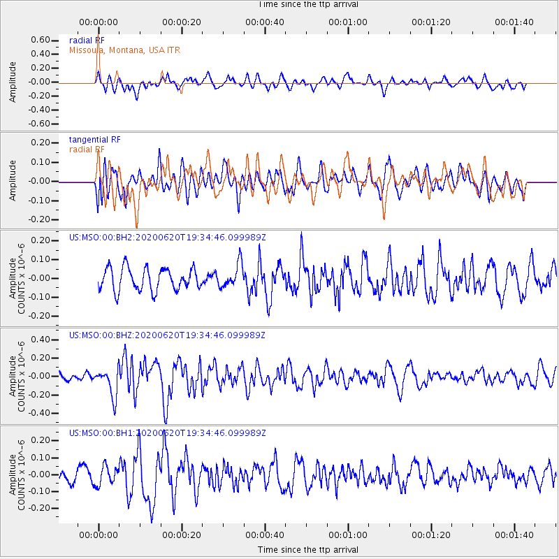
Signal To Noise
| Channel | StoN | STA | LTA |
| US:MSO:00:BHZ:20200620T19:34:46.099989Z | 3.2387247 | 1.5791929E-7 | 4.8759713E-8 |
| US:MSO:00:BH1:20200620T19:34:46.099989Z | 0.8787557 | 5.5080413E-8 | 6.268001E-8 |
| US:MSO:00:BH2:20200620T19:34:46.099989Z | 1.1107312 | 6.577596E-8 | 5.9218603E-8 |
| Arrivals |
| Ps | |
| PpPs | |
| PsPs/PpSs | |


