You are here: Home > Network List > IW - Intermountain West Stations List
> Station MOOW Moose Ponds, Wyoming, USA > Earthquake Result Viewer
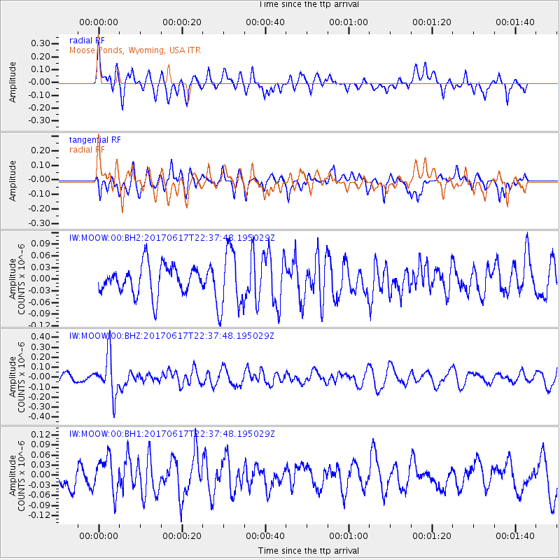
MOOW Moose Ponds, Wyoming, USA - Earthquake Result Viewer
*The percent match for this event was below the threshold and hence no stack was calculated.
| Earthquake location: |
South Of Fiji Islands |
| Earthquake latitude/longitude: |
-24.1/179.6 |
| Earthquake time(UTC): |
2017/06/17 (168) 22:26:02 GMT |
| Earthquake Depth: |
518 km |
| Earthquake Magnitude: |
6.1 Mww |
| Earthquake Catalog/Contributor: |
NEIC PDE/us |
|
| Network: |
IW Intermountain West |
| Station: |
MOOW Moose Ponds, Wyoming, USA |
| Lat/Lon: |
43.75 N/110.74 W |
| Elevation: |
2128 m |
|
| Distance: |
92.8 deg |
| Az: |
42.872 deg |
| Baz: |
239.084 deg |
| Ray Param: |
$rayparam |
*The percent match for this event was below the threshold and hence was not used in the summary stack. |
|
| Radial Match: |
54.3581 % |
| Radial Bump: |
400 |
| Transverse Match: |
62.857597 % |
| Transverse Bump: |
400 |
| SOD ConfigId: |
2140511 |
| Insert Time: |
2017-07-01 14:22:57.501 +0000 |
| GWidth: |
2.5 |
| Max Bumps: |
400 |
| Tol: |
0.001 |
|
Signal To Noise
| Channel | StoN | STA | LTA |
| IW:MOOW:00:BHZ:20170617T22:37:48.195029Z | 4.938995 | 2.0487914E-7 | 4.148195E-8 |
| IW:MOOW:00:BH1:20170617T22:37:48.195029Z | 2.0182552 | 5.448089E-8 | 2.6994051E-8 |
| IW:MOOW:00:BH2:20170617T22:37:48.195029Z | 2.0972028 | 7.7378225E-8 | 3.689592E-8 |
| Arrivals |
| Ps | |
| PpPs | |
| PsPs/PpSs | |


