You are here: Home > Network List > AK - Alaska Regional Network Stations List
> Station H22K Ishtalitna Creek, AK, USA > Earthquake Result Viewer
H22K Ishtalitna Creek, AK, USA - Earthquake Result Viewer
| Earthquake location: |
Iceland Region |
| Earthquake latitude/longitude: |
66.4/-18.7 |
| Earthquake time(UTC): |
2020/06/21 (173) 19:07:55 GMT |
| Earthquake Depth: |
10 km |
| Earthquake Magnitude: |
6.0 mww |
| Earthquake Catalog/Contributor: |
NEIC PDE/us |
|
| Network: |
AK Alaska Regional Network |
| Station: |
H22K Ishtalitna Creek, AK, USA |
| Lat/Lon: |
65.89 N/151.38 W |
| Elevation: |
561 m |
|
| Distance: |
43.8 deg |
| Az: |
334.115 deg |
| Baz: |
25.349 deg |
| Ray Param: |
0.07235198 |
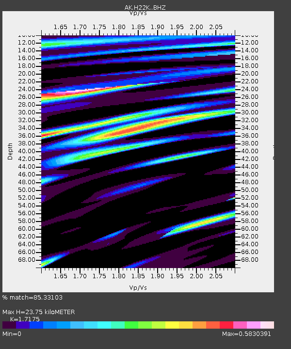
| Estimated Moho Depth: |
23.75 km |
| Estimated Crust Vp/Vs: |
1.72 |
| Assumed Crust Vp: |
6.566 km/s |
| Estimated Crust Vs: |
3.823 km/s |
| Estimated Crust Poisson's Ratio: |
0.24 |
|
| Radial Match: |
85.33103 % |
| Radial Bump: |
400 |
| Transverse Match: |
72.25784 % |
| Transverse Bump: |
400 |
| SOD ConfigId: |
21709731 |
| Insert Time: |
2020-07-05 19:10:05.081 +0000 |
| GWidth: |
2.5 |
| Max Bumps: |
400 |
| Tol: |
0.001 |
|

Signal To Noise
| Channel | StoN | STA | LTA |
| AK:H22K: :BHZ:20200621T19:15:29.620012Z | 3.2044456 | 1.8703672E-7 | 5.836789E-8 |
| AK:H22K: :BHN:20200621T19:15:29.620012Z | 1.5857768 | 8.441343E-8 | 5.32316E-8 |
| AK:H22K: :BHE:20200621T19:15:29.620012Z | 1.9552376 | 1.0282927E-7 | 5.2591698E-8 |
| Arrivals |
| Ps | 2.8 SECOND |
| PpPs | 9.2 SECOND |
| PsPs/PpSs | 12 SECOND |


