You are here: Home > Network List > AK - Alaska Regional Network Stations List
> Station I27K Kandik River, AK, USA > Earthquake Result Viewer
I27K Kandik River, AK, USA - Earthquake Result Viewer
| Earthquake location: |
Iceland Region |
| Earthquake latitude/longitude: |
66.4/-18.7 |
| Earthquake time(UTC): |
2020/06/21 (173) 19:07:55 GMT |
| Earthquake Depth: |
10 km |
| Earthquake Magnitude: |
6.0 mww |
| Earthquake Catalog/Contributor: |
NEIC PDE/us |
|
| Network: |
AK Alaska Regional Network |
| Station: |
I27K Kandik River, AK, USA |
| Lat/Lon: |
65.60 N/141.62 W |
| Elevation: |
874 m |
|
| Distance: |
42.1 deg |
| Az: |
328.685 deg |
| Baz: |
30.266 deg |
| Ray Param: |
0.07335625 |
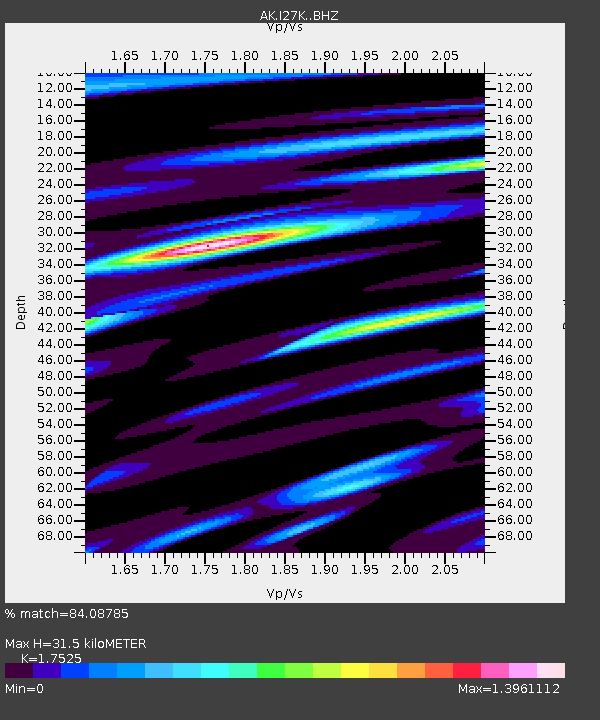
| Estimated Moho Depth: |
31.5 km |
| Estimated Crust Vp/Vs: |
1.75 |
| Assumed Crust Vp: |
6.566 km/s |
| Estimated Crust Vs: |
3.747 km/s |
| Estimated Crust Poisson's Ratio: |
0.26 |
|
| Radial Match: |
84.08785 % |
| Radial Bump: |
400 |
| Transverse Match: |
61.025734 % |
| Transverse Bump: |
400 |
| SOD ConfigId: |
21709731 |
| Insert Time: |
2020-07-05 19:10:20.236 +0000 |
| GWidth: |
2.5 |
| Max Bumps: |
400 |
| Tol: |
0.001 |
|

Signal To Noise
| Channel | StoN | STA | LTA |
| AK:I27K: :BHZ:20200621T19:15:16.479998Z | 7.097156 | 4.291316E-7 | 6.046529E-8 |
| AK:I27K: :BHN:20200621T19:15:16.479998Z | 4.207866 | 2.2919112E-7 | 5.44673E-8 |
| AK:I27K: :BHE:20200621T19:15:16.479998Z | 2.3322287 | 9.925813E-8 | 4.2559346E-8 |
| Arrivals |
| Ps | 3.9 SECOND |
| PpPs | 12 SECOND |
| PsPs/PpSs | 16 SECOND |


