You are here: Home > Network List > AV - Alaska Volcano Observatory Stations List
> Station SPCR Ckakachatna River, Mount Spurr, Alaska > Earthquake Result Viewer
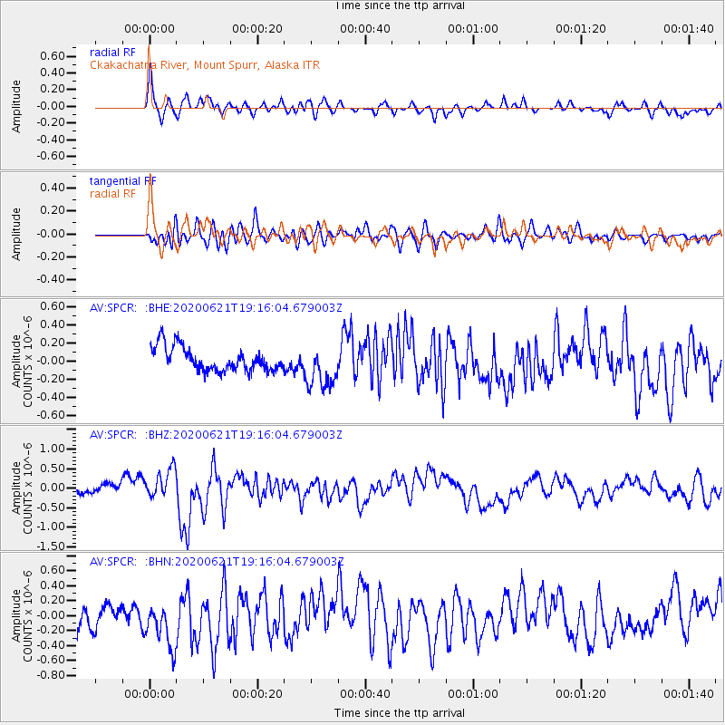
SPCR Ckakachatna River, Mount Spurr, Alaska - Earthquake Result Viewer
*The percent match for this event was below the threshold and hence no stack was calculated.
| Earthquake location: |
Iceland Region |
| Earthquake latitude/longitude: |
66.4/-18.7 |
| Earthquake time(UTC): |
2020/06/21 (173) 19:07:55 GMT |
| Earthquake Depth: |
10 km |
| Earthquake Magnitude: |
6.0 mww |
| Earthquake Catalog/Contributor: |
NEIC PDE/us |
|
| Network: |
AV Alaska Volcano Observatory |
| Station: |
SPCR Ckakachatna River, Mount Spurr, Alaska |
| Lat/Lon: |
61.20 N/152.21 W |
| Elevation: |
984 m |
|
| Distance: |
48.2 deg |
| Az: |
331.901 deg |
| Baz: |
23.065 deg |
| Ray Param: |
$rayparam |
*The percent match for this event was below the threshold and hence was not used in the summary stack. |
|
| Radial Match: |
73.2519 % |
| Radial Bump: |
400 |
| Transverse Match: |
54.724525 % |
| Transverse Bump: |
400 |
| SOD ConfigId: |
21709731 |
| Insert Time: |
2020-07-05 19:13:31.171 +0000 |
| GWidth: |
2.5 |
| Max Bumps: |
400 |
| Tol: |
0.001 |
|
Signal To Noise
| Channel | StoN | STA | LTA |
| AV:SPCR: :BHZ:20200621T19:16:04.679003Z | 3.2515519 | 3.8722948E-7 | 1.1909067E-7 |
| AV:SPCR: :BHN:20200621T19:16:04.679003Z | 2.2854276 | 3.443089E-7 | 1.5065405E-7 |
| AV:SPCR: :BHE:20200621T19:16:04.679003Z | 1.8415674 | 2.4112387E-7 | 1.3093405E-7 |
| Arrivals |
| Ps | |
| PpPs | |
| PsPs/PpSs | |


