You are here: Home > Network List > US - United States National Seismic Network Stations List
> Station MNTX Cornudas Mountains, Texas, USA > Earthquake Result Viewer
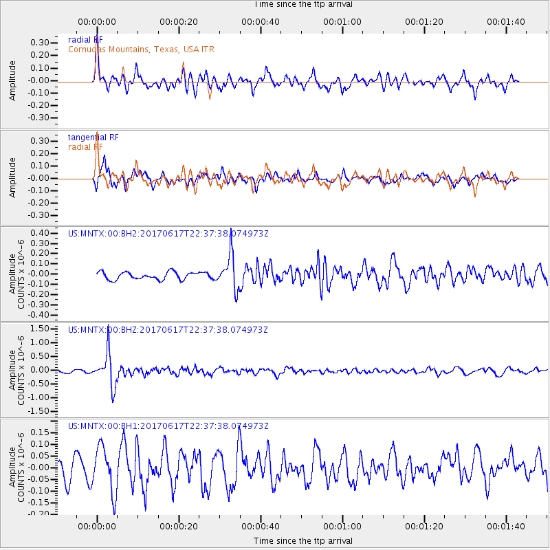
MNTX Cornudas Mountains, Texas, USA - Earthquake Result Viewer
*The percent match for this event was below the threshold and hence no stack was calculated.
| Earthquake location: |
South Of Fiji Islands |
| Earthquake latitude/longitude: |
-24.1/179.6 |
| Earthquake time(UTC): |
2017/06/17 (168) 22:26:02 GMT |
| Earthquake Depth: |
518 km |
| Earthquake Magnitude: |
6.1 Mww |
| Earthquake Catalog/Contributor: |
NEIC PDE/us |
|
| Network: |
US United States National Seismic Network |
| Station: |
MNTX Cornudas Mountains, Texas, USA |
| Lat/Lon: |
31.70 N/105.38 W |
| Elevation: |
404 m |
|
| Distance: |
90.6 deg |
| Az: |
55.437 deg |
| Baz: |
241.987 deg |
| Ray Param: |
$rayparam |
*The percent match for this event was below the threshold and hence was not used in the summary stack. |
|
| Radial Match: |
70.65447 % |
| Radial Bump: |
400 |
| Transverse Match: |
67.374245 % |
| Transverse Bump: |
400 |
| SOD ConfigId: |
2140511 |
| Insert Time: |
2017-07-01 14:24:50.377 +0000 |
| GWidth: |
2.5 |
| Max Bumps: |
400 |
| Tol: |
0.001 |
|
Signal To Noise
| Channel | StoN | STA | LTA |
| US:MNTX:00:BHZ:20170617T22:37:38.074973Z | 12.340241 | 6.113803E-7 | 4.9543626E-8 |
| US:MNTX:00:BH1:20170617T22:37:38.074973Z | 2.3729134 | 9.969188E-8 | 4.201244E-8 |
| US:MNTX:00:BH2:20170617T22:37:38.074973Z | 4.6169834 | 1.7131764E-7 | 3.710597E-8 |
| Arrivals |
| Ps | |
| PpPs | |
| PsPs/PpSs | |


