You are here: Home > Network List > C0 - Colorado Geological Survey Seismic Network Stations List
> Station T25A Trinidad, CO > Earthquake Result Viewer
T25A Trinidad, CO - Earthquake Result Viewer
| Earthquake location: |
Iceland Region |
| Earthquake latitude/longitude: |
66.4/-18.7 |
| Earthquake time(UTC): |
2020/06/21 (173) 19:07:55 GMT |
| Earthquake Depth: |
10 km |
| Earthquake Magnitude: |
6.0 mww |
| Earthquake Catalog/Contributor: |
NEIC PDE/us |
|
| Network: |
C0 Colorado Geological Survey Seismic Network |
| Station: |
T25A Trinidad, CO |
| Lat/Lon: |
37.08 N/104.25 W |
| Elevation: |
1800 m |
|
| Distance: |
54.9 deg |
| Az: |
283.074 deg |
| Baz: |
29.381 deg |
| Ray Param: |
0.06513135 |
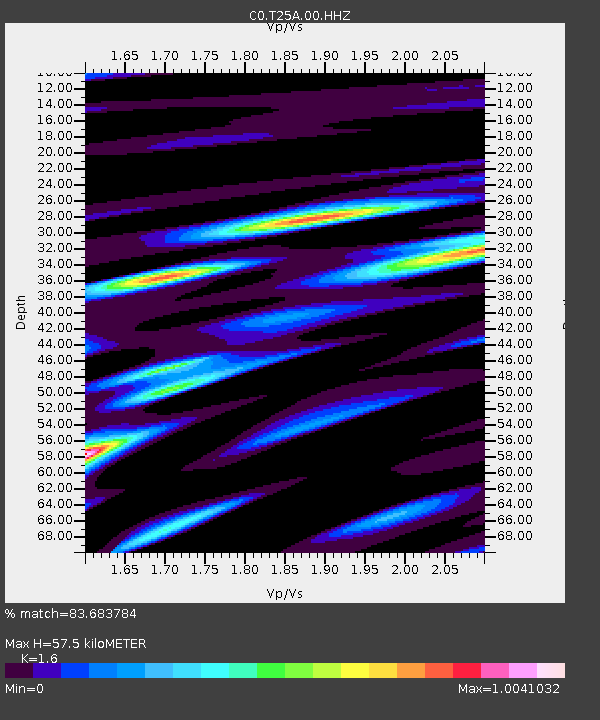
| Estimated Moho Depth: |
57.5 km |
| Estimated Crust Vp/Vs: |
1.60 |
| Assumed Crust Vp: |
6.316 km/s |
| Estimated Crust Vs: |
3.947 km/s |
| Estimated Crust Poisson's Ratio: |
0.18 |
|
| Radial Match: |
83.683784 % |
| Radial Bump: |
267 |
| Transverse Match: |
61.273186 % |
| Transverse Bump: |
393 |
| SOD ConfigId: |
21709731 |
| Insert Time: |
2020-07-05 19:14:51.911 +0000 |
| GWidth: |
2.5 |
| Max Bumps: |
400 |
| Tol: |
0.001 |
|

Signal To Noise
| Channel | StoN | STA | LTA |
| C0:T25A:00:HHZ:20200621T19:16:55.079973Z | 7.29162 | 3.3915362E-7 | 4.6512795E-8 |
| C0:T25A:00:HHN:20200621T19:16:55.079973Z | 3.5163252 | 1.7938382E-7 | 5.101457E-8 |
| C0:T25A:00:HHE:20200621T19:16:55.079973Z | 1.9032934 | 1.209741E-7 | 6.356041E-8 |
| Arrivals |
| Ps | 5.8 SECOND |
| PpPs | 22 SECOND |
| PsPs/PpSs | 28 SECOND |


