You are here: Home > Network List > CO - South Carolina Seismic Network Stations List
> Station CASEE Lake Jocassee, SC, USA > Earthquake Result Viewer
CASEE Lake Jocassee, SC, USA - Earthquake Result Viewer
| Earthquake location: |
Iceland Region |
| Earthquake latitude/longitude: |
66.4/-18.7 |
| Earthquake time(UTC): |
2020/06/21 (173) 19:07:55 GMT |
| Earthquake Depth: |
10 km |
| Earthquake Magnitude: |
6.0 mww |
| Earthquake Catalog/Contributor: |
NEIC PDE/us |
|
| Network: |
CO South Carolina Seismic Network |
| Station: |
CASEE Lake Jocassee, SC, USA |
| Lat/Lon: |
34.99 N/82.93 W |
| Elevation: |
385 m |
|
| Distance: |
48.2 deg |
| Az: |
262.557 deg |
| Baz: |
29.108 deg |
| Ray Param: |
0.069505975 |
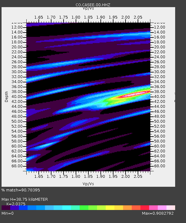
| Estimated Moho Depth: |
38.75 km |
| Estimated Crust Vp/Vs: |
2.04 |
| Assumed Crust Vp: |
6.35 km/s |
| Estimated Crust Vs: |
3.117 km/s |
| Estimated Crust Poisson's Ratio: |
0.34 |
|
| Radial Match: |
90.78395 % |
| Radial Bump: |
318 |
| Transverse Match: |
61.029064 % |
| Transverse Bump: |
400 |
| SOD ConfigId: |
21709731 |
| Insert Time: |
2020-07-05 19:19:40.228 +0000 |
| GWidth: |
2.5 |
| Max Bumps: |
400 |
| Tol: |
0.001 |
|

Signal To Noise
| Channel | StoN | STA | LTA |
| CO:CASEE:00:HHZ:20200621T19:16:04.837999Z | 7.560555 | 4.3240973E-7 | 5.719286E-8 |
| CO:CASEE:00:HHN:20200621T19:16:04.837999Z | 6.034684 | 2.7476287E-7 | 4.5530612E-8 |
| CO:CASEE:00:HHE:20200621T19:16:04.837999Z | 5.3149033 | 1.8246608E-7 | 3.4331027E-8 |
| Arrivals |
| Ps | 6.7 SECOND |
| PpPs | 18 SECOND |
| PsPs/PpSs | 24 SECOND |


