You are here: Home > Network List > GS - US Geological Survey Networks Stations List
> Station OK038 West end E0370 Rd, Waynoka, OK, USA > Earthquake Result Viewer
OK038 West end E0370 Rd, Waynoka, OK, USA - Earthquake Result Viewer
| Earthquake location: |
Iceland Region |
| Earthquake latitude/longitude: |
66.4/-18.7 |
| Earthquake time(UTC): |
2020/06/21 (173) 19:07:55 GMT |
| Earthquake Depth: |
10 km |
| Earthquake Magnitude: |
6.0 mww |
| Earthquake Catalog/Contributor: |
NEIC PDE/us |
|
| Network: |
GS US Geological Survey Networks |
| Station: |
OK038 West end E0370 Rd, Waynoka, OK, USA |
| Lat/Lon: |
36.48 N/98.74 W |
| Elevation: |
443 m |
|
| Distance: |
53.3 deg |
| Az: |
277.961 deg |
| Baz: |
29.665 deg |
| Ray Param: |
0.06621769 |
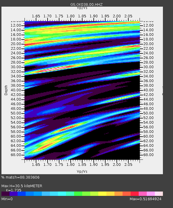
| Estimated Moho Depth: |
30.5 km |
| Estimated Crust Vp/Vs: |
1.74 |
| Assumed Crust Vp: |
6.426 km/s |
| Estimated Crust Vs: |
3.704 km/s |
| Estimated Crust Poisson's Ratio: |
0.25 |
|
| Radial Match: |
88.383606 % |
| Radial Bump: |
400 |
| Transverse Match: |
59.94986 % |
| Transverse Bump: |
400 |
| SOD ConfigId: |
21709731 |
| Insert Time: |
2020-07-05 19:21:22.477 +0000 |
| GWidth: |
2.5 |
| Max Bumps: |
400 |
| Tol: |
0.001 |
|

Signal To Noise
| Channel | StoN | STA | LTA |
| GS:OK038:00:HHZ:20200621T19:16:42.928972Z | 5.387175 | 5.5387403E-7 | 1.02813445E-7 |
| GS:OK038:00:HH1:20200621T19:16:42.928972Z | 3.3910723 | 5.6348273E-7 | 1.6616654E-7 |
| GS:OK038:00:HH2:20200621T19:16:42.928972Z | 1.4613403 | 2.0314731E-7 | 1.3901438E-7 |
| Arrivals |
| Ps | 3.7 SECOND |
| PpPs | 12 SECOND |
| PsPs/PpSs | 16 SECOND |


