You are here: Home > Network List > IW - Intermountain West Stations List
> Station MOOW Moose Ponds, Wyoming, USA > Earthquake Result Viewer
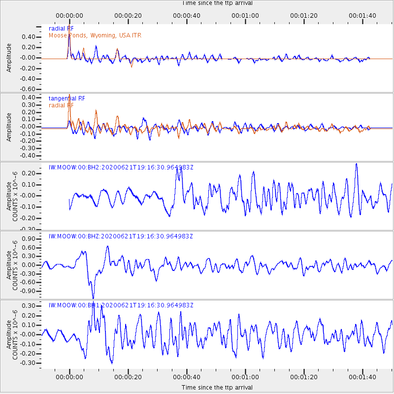
MOOW Moose Ponds, Wyoming, USA - Earthquake Result Viewer
*The percent match for this event was below the threshold and hence no stack was calculated.
| Earthquake location: |
Iceland Region |
| Earthquake latitude/longitude: |
66.4/-18.7 |
| Earthquake time(UTC): |
2020/06/21 (173) 19:07:55 GMT |
| Earthquake Depth: |
10 km |
| Earthquake Magnitude: |
6.0 mww |
| Earthquake Catalog/Contributor: |
NEIC PDE/us |
|
| Network: |
IW Intermountain West |
| Station: |
MOOW Moose Ponds, Wyoming, USA |
| Lat/Lon: |
43.75 N/110.74 W |
| Elevation: |
2128 m |
|
| Distance: |
51.7 deg |
| Az: |
292.593 deg |
| Baz: |
30.874 deg |
| Ray Param: |
$rayparam |
*The percent match for this event was below the threshold and hence was not used in the summary stack. |
|
| Radial Match: |
78.278076 % |
| Radial Bump: |
400 |
| Transverse Match: |
65.41879 % |
| Transverse Bump: |
400 |
| SOD ConfigId: |
21709731 |
| Insert Time: |
2020-07-05 19:23:14.518 +0000 |
| GWidth: |
2.5 |
| Max Bumps: |
400 |
| Tol: |
0.001 |
|
Signal To Noise
| Channel | StoN | STA | LTA |
| IW:MOOW:00:BHZ:20200621T19:16:30.964983Z | 3.7705274 | 2.4257542E-7 | 6.4334614E-8 |
| IW:MOOW:00:BH1:20200621T19:16:30.964983Z | 1.8699688 | 7.436567E-8 | 3.9768405E-8 |
| IW:MOOW:00:BH2:20200621T19:16:30.964983Z | 1.9321492 | 8.912453E-8 | 4.612715E-8 |
| Arrivals |
| Ps | |
| PpPs | |
| PsPs/PpSs | |


