You are here: Home > Network List > N4 - Central and EAstern US Network Stations List
> Station P48A Milroy, IN, USA > Earthquake Result Viewer
P48A Milroy, IN, USA - Earthquake Result Viewer
| Earthquake location: |
Iceland Region |
| Earthquake latitude/longitude: |
66.4/-18.7 |
| Earthquake time(UTC): |
2020/06/21 (173) 19:07:55 GMT |
| Earthquake Depth: |
10 km |
| Earthquake Magnitude: |
6.0 mww |
| Earthquake Catalog/Contributor: |
NEIC PDE/us |
|
| Network: |
N4 Central and EAstern US Network |
| Station: |
P48A Milroy, IN, USA |
| Lat/Lon: |
39.46 N/85.43 W |
| Elevation: |
300 m |
|
| Distance: |
45.4 deg |
| Az: |
267.997 deg |
| Baz: |
31.33 deg |
| Ray Param: |
0.07133038 |
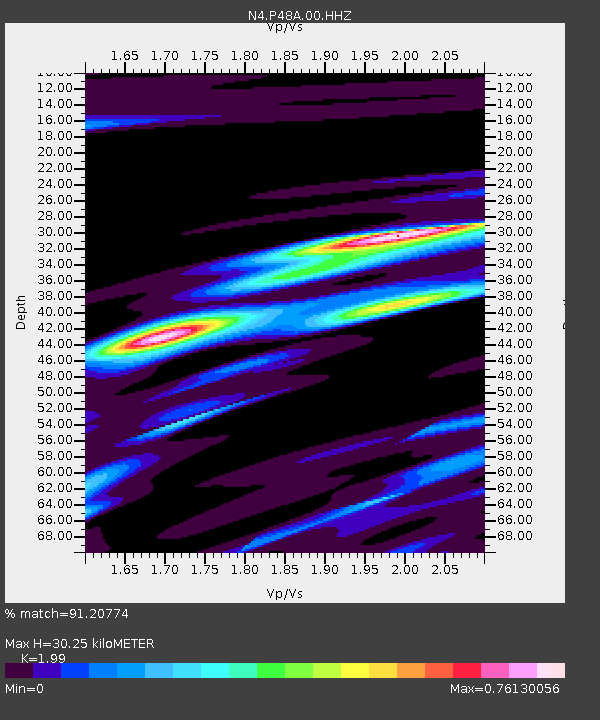
| Estimated Moho Depth: |
30.25 km |
| Estimated Crust Vp/Vs: |
1.99 |
| Assumed Crust Vp: |
6.498 km/s |
| Estimated Crust Vs: |
3.265 km/s |
| Estimated Crust Poisson's Ratio: |
0.33 |
|
| Radial Match: |
91.20774 % |
| Radial Bump: |
213 |
| Transverse Match: |
73.17852 % |
| Transverse Bump: |
372 |
| SOD ConfigId: |
21709731 |
| Insert Time: |
2020-07-05 19:27:04.150 +0000 |
| GWidth: |
2.5 |
| Max Bumps: |
400 |
| Tol: |
0.001 |
|

Signal To Noise
| Channel | StoN | STA | LTA |
| N4:P48A:00:HHZ:20200621T19:15:42.539995Z | 12.879538 | 5.913593E-7 | 4.591464E-8 |
| N4:P48A:00:HH1:20200621T19:15:42.539995Z | 6.965507 | 3.1094837E-7 | 4.4641165E-8 |
| N4:P48A:00:HH2:20200621T19:15:42.539995Z | 5.1378436 | 1.9310731E-7 | 3.7585284E-8 |
| Arrivals |
| Ps | 4.9 SECOND |
| PpPs | 13 SECOND |
| PsPs/PpSs | 18 SECOND |


