You are here: Home > Network List > N4 - Central and EAstern US Network Stations List
> Station U49A Red Boiling Springs, TN, USA > Earthquake Result Viewer
U49A Red Boiling Springs, TN, USA - Earthquake Result Viewer
| Earthquake location: |
Iceland Region |
| Earthquake latitude/longitude: |
66.4/-18.7 |
| Earthquake time(UTC): |
2020/06/21 (173) 19:07:55 GMT |
| Earthquake Depth: |
10 km |
| Earthquake Magnitude: |
6.0 mww |
| Earthquake Catalog/Contributor: |
NEIC PDE/us |
|
| Network: |
N4 Central and EAstern US Network |
| Station: |
U49A Red Boiling Springs, TN, USA |
| Lat/Lon: |
36.51 N/85.78 W |
| Elevation: |
234 m |
|
| Distance: |
48.0 deg |
| Az: |
266.268 deg |
| Baz: |
29.927 deg |
| Ray Param: |
0.06962294 |
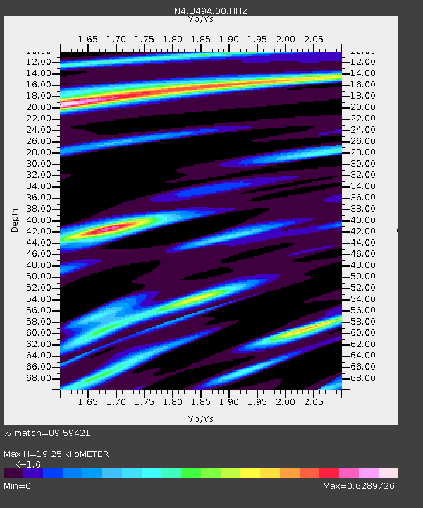
| Estimated Moho Depth: |
19.25 km |
| Estimated Crust Vp/Vs: |
1.60 |
| Assumed Crust Vp: |
6.476 km/s |
| Estimated Crust Vs: |
4.047 km/s |
| Estimated Crust Poisson's Ratio: |
0.18 |
|
| Radial Match: |
89.59421 % |
| Radial Bump: |
351 |
| Transverse Match: |
75.392265 % |
| Transverse Bump: |
400 |
| SOD ConfigId: |
21709731 |
| Insert Time: |
2020-07-05 19:27:51.392 +0000 |
| GWidth: |
2.5 |
| Max Bumps: |
400 |
| Tol: |
0.001 |
|

Signal To Noise
| Channel | StoN | STA | LTA |
| N4:U49A:00:HHZ:20200621T19:16:03.460009Z | 9.397309 | 5.655048E-7 | 6.0177314E-8 |
| N4:U49A:00:HH1:20200621T19:16:03.460009Z | 6.643111 | 2.3561516E-7 | 3.5467593E-8 |
| N4:U49A:00:HH2:20200621T19:16:03.460009Z | 5.5709543 | 1.7563548E-7 | 3.1527E-8 |
| Arrivals |
| Ps | 1.9 SECOND |
| PpPs | 7.2 SECOND |
| PsPs/PpSs | 9.1 SECOND |


