You are here: Home > Network List > WY - Yellowstone Wyoming Seismic Network Stations List
> Station YPP Pitchstone Plateau, YNP, WY, USA > Earthquake Result Viewer
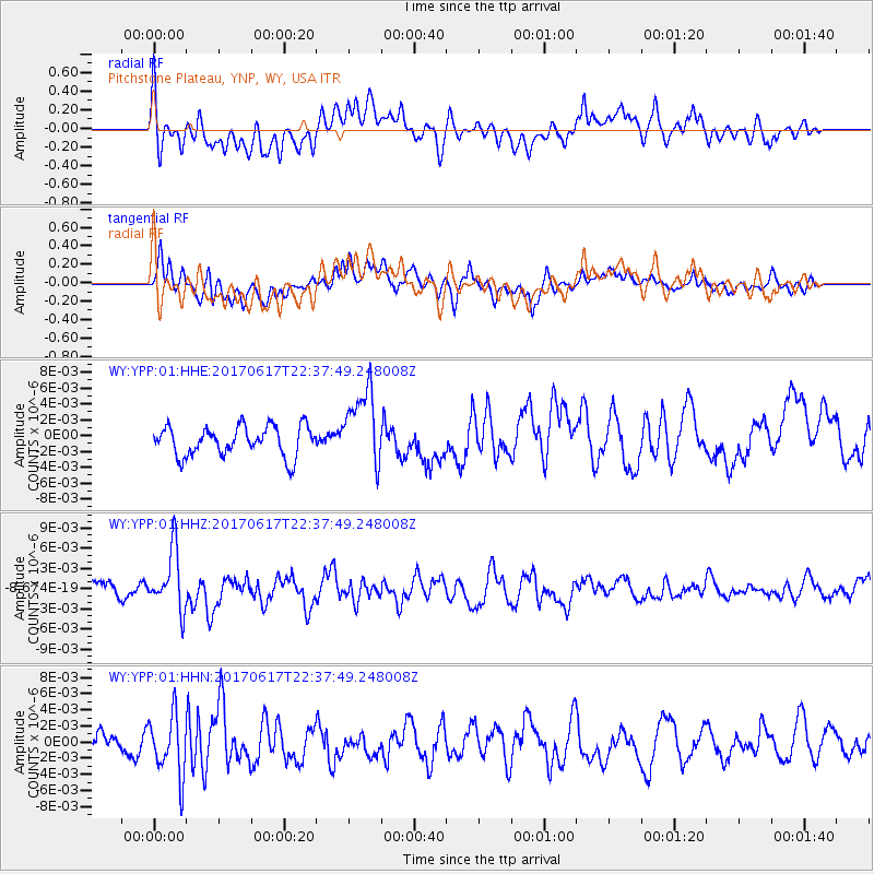
YPP Pitchstone Plateau, YNP, WY, USA - Earthquake Result Viewer
*The percent match for this event was below the threshold and hence no stack was calculated.
| Earthquake location: |
South Of Fiji Islands |
| Earthquake latitude/longitude: |
-24.1/179.6 |
| Earthquake time(UTC): |
2017/06/17 (168) 22:26:02 GMT |
| Earthquake Depth: |
518 km |
| Earthquake Magnitude: |
6.1 Mww |
| Earthquake Catalog/Contributor: |
NEIC PDE/us |
|
| Network: |
WY Yellowstone Wyoming Seismic Network |
| Station: |
YPP Pitchstone Plateau, YNP, WY, USA |
| Lat/Lon: |
44.27 N/110.80 W |
| Elevation: |
2707 m |
|
| Distance: |
93.1 deg |
| Az: |
42.402 deg |
| Baz: |
239.067 deg |
| Ray Param: |
$rayparam |
*The percent match for this event was below the threshold and hence was not used in the summary stack. |
|
| Radial Match: |
61.461758 % |
| Radial Bump: |
400 |
| Transverse Match: |
56.630707 % |
| Transverse Bump: |
400 |
| SOD ConfigId: |
2140511 |
| Insert Time: |
2017-07-01 14:28:07.572 +0000 |
| GWidth: |
2.5 |
| Max Bumps: |
400 |
| Tol: |
0.001 |
|
Signal To Noise
| Channel | StoN | STA | LTA |
| WY:YPP:01:HHZ:20170617T22:37:49.248008Z | 3.2490637 | 4.3943365E-9 | 1.3524931E-9 |
| WY:YPP:01:HHN:20170617T22:37:49.248008Z | 2.5426016 | 3.6858463E-9 | 1.4496357E-9 |
| WY:YPP:01:HHE:20170617T22:37:49.248008Z | 2.622854 | 4.865323E-9 | 1.8549727E-9 |
| Arrivals |
| Ps | |
| PpPs | |
| PsPs/PpSs | |


