You are here: Home > Network List > NE - New England Seismic Network Stations List
> Station EMMW Machias, ME, USA > Earthquake Result Viewer
EMMW Machias, ME, USA - Earthquake Result Viewer
| Earthquake location: |
Iceland Region |
| Earthquake latitude/longitude: |
66.4/-18.7 |
| Earthquake time(UTC): |
2020/06/21 (173) 19:07:55 GMT |
| Earthquake Depth: |
10 km |
| Earthquake Magnitude: |
6.0 mww |
| Earthquake Catalog/Contributor: |
NEIC PDE/us |
|
| Network: |
NE New England Seismic Network |
| Station: |
EMMW Machias, ME, USA |
| Lat/Lon: |
44.71 N/67.46 W |
| Elevation: |
35 m |
|
| Distance: |
33.8 deg |
| Az: |
254.595 deg |
| Baz: |
32.995 deg |
| Ray Param: |
0.078057736 |
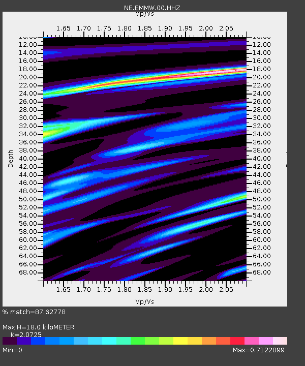
| Estimated Moho Depth: |
18.0 km |
| Estimated Crust Vp/Vs: |
2.07 |
| Assumed Crust Vp: |
6.419 km/s |
| Estimated Crust Vs: |
3.097 km/s |
| Estimated Crust Poisson's Ratio: |
0.35 |
|
| Radial Match: |
87.62778 % |
| Radial Bump: |
400 |
| Transverse Match: |
53.23014 % |
| Transverse Bump: |
400 |
| SOD ConfigId: |
21709731 |
| Insert Time: |
2020-07-05 19:28:29.371 +0000 |
| GWidth: |
2.5 |
| Max Bumps: |
400 |
| Tol: |
0.001 |
|

Signal To Noise
| Channel | StoN | STA | LTA |
| NE:EMMW:00:HHZ:20200621T19:14:06.348986Z | 5.741103 | 5.6474323E-7 | 9.836841E-8 |
| NE:EMMW:00:HH1:20200621T19:14:06.348986Z | 2.872631 | 3.3524813E-7 | 1.16704214E-7 |
| NE:EMMW:00:HH2:20200621T19:14:06.348986Z | 2.855993 | 2.1839396E-7 | 7.646866E-8 |
| Arrivals |
| Ps | 3.2 SECOND |
| PpPs | 8.1 SECOND |
| PsPs/PpSs | 11 SECOND |


